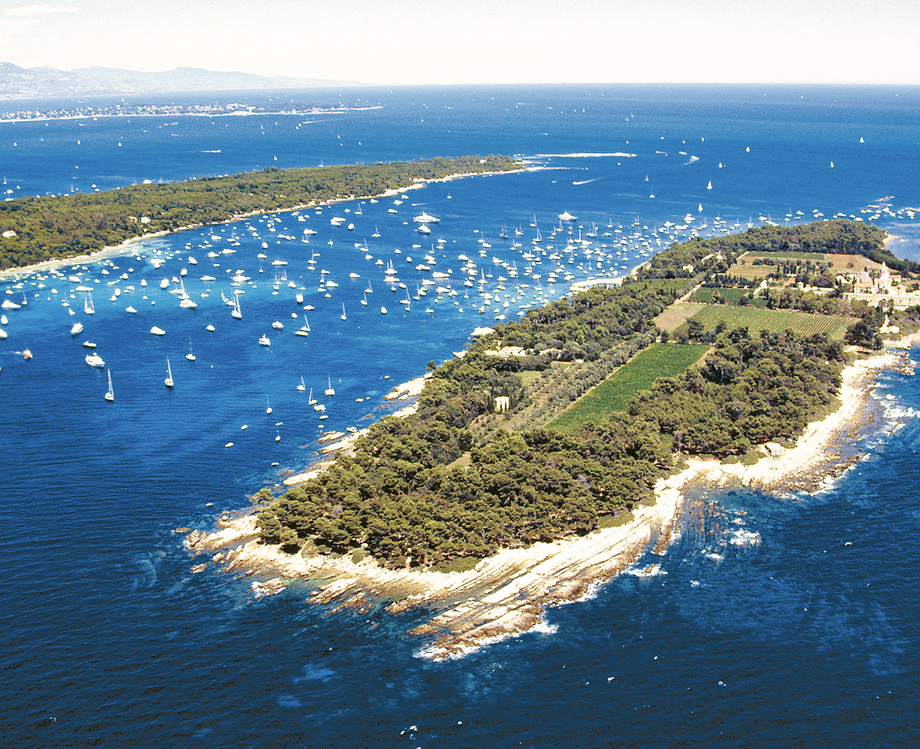


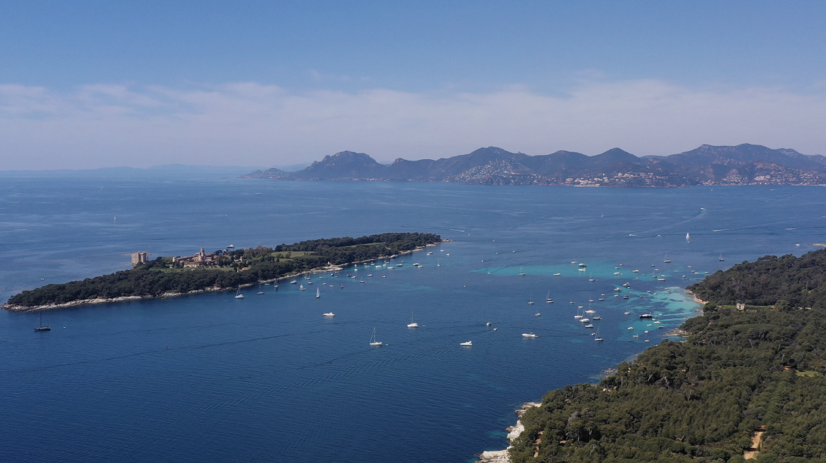
A view on the monastery from the South of the Saint-Honorat island. In the background, the island of Sainte-Marguerite and the mainland further away.
The islands and their history
- Sainte-Marguerite
-
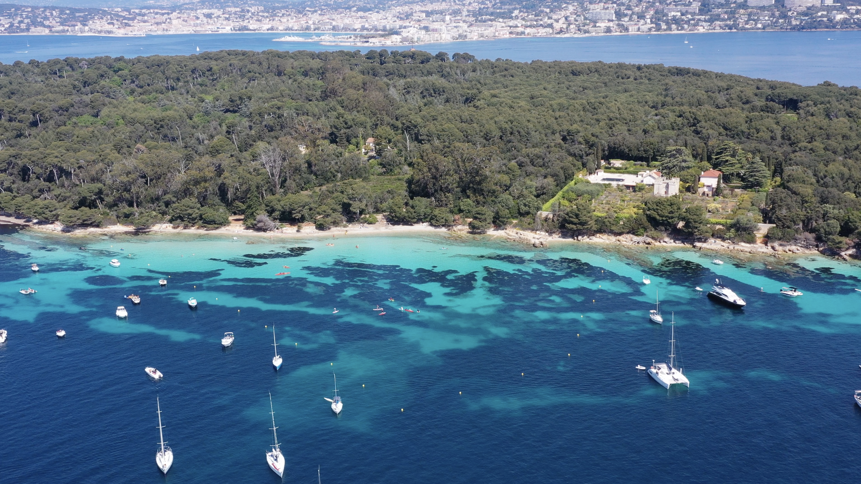
The largest of the islands is also the closest to Cannes, less than a kilometer from the tip of the Croisette. Sainte-Marguerite extends over about 3 km and 170Ha, you have to walk 8km to go around it. Classified as Natura 2000 since 1930 and more recently as a natural zone of ecological, floristic and faunistic interest (ZNIEFF), the forest which covers 90% of the island belongs to the state. The ONF sees it as a relic of what was the local coastline a hundred years ago. About twenty protected plant species have taken up residence there. Some of them, like the Sea Lily or the Sea Buckthorn, are found nowhere else in the Alpes-Maritimes. If in the past exotic species were introduced on the island, the ONF is now working to return to a natural local formation (Aleppo pine and holm oak mainly) left in free evolution. To the west of the island, the Etang du Batéguier is home to many species of migratory birds such as the common tern or the grey heron. In all, more than 130 species of birds have been recorded on the island, as well as several species of bats and reptiles (Montpellier snake) and many beetles (Great Capricorn) and lepidopterans (butterflies).
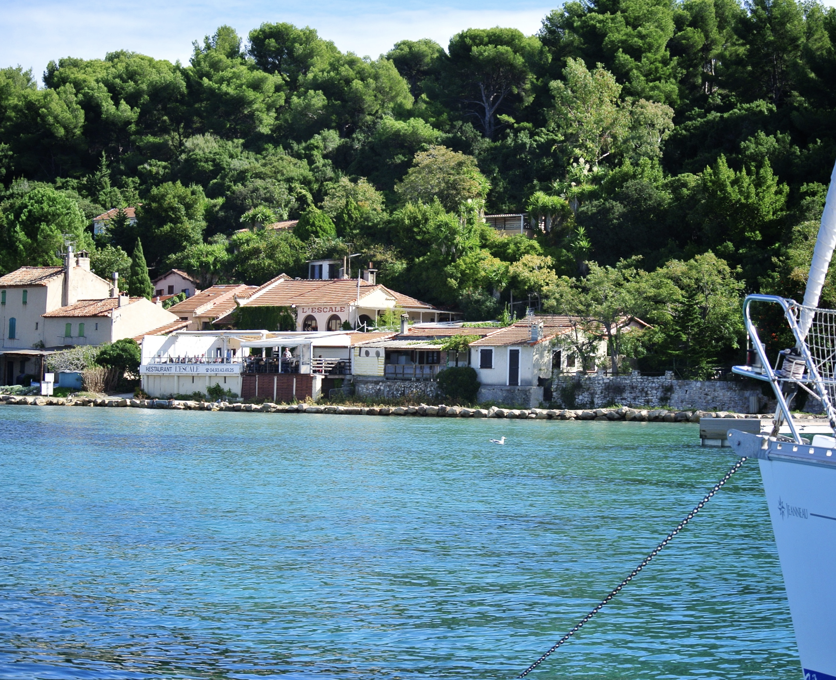
Fort Royal on Saint-Marguerite, with a restaurant to the left, the shipyard to the right and the port area and the Etang du Bateguier (pond) further to the right. In the background, Saint-Honorat on the left and the Esterel ridge that creates the very distinctive skyline.
Let's go back in time. The first traces of occupation of the island, then called Léro, date back 2500 years. About 2000 years ago, the Romans settled on the island. In the Middle Age, the archipelago was used as an outpost and was the site of many battles. The first fortifications of Sainte-Marguerite date back to 1630, at the same time the Batéguier tower was erected at the northwestern tip of the island. During the 30 years war, these fortifications were modified by the Spanish during their control of the archipelago around 1635.
After the recovery of the area by Richelieu, the present Fort Royal was built in the middle of the 17th century. It was then that the state prison was established in Sainte-Marguerite. In 1687, a new governor arrived on the island, with one of his most famous prisoners: the man in the iron mask. Other troublesome characters were sent to the island in the wake of various oppositions, such as pastors after the revocation of the Edict of Nantes, a marquis after a love affair with the Count of Arbois, and children whose parents were no longer able to educate them. During the revolution, the state prison became a military prison and continued to "welcome" different populations over time: royalists and ecclesiastics under the Empire, then Bonaparte's mamelukes upon his abdication, hundreds of families after the capture of Smala (conquest of Algeria, 1843), hundreds of Austrian soldiers after the battle of Montebello (Italian campaign, 1859) and Marshal Bazaine after the French rout against the German states (Franco-Prussian war, 1870).
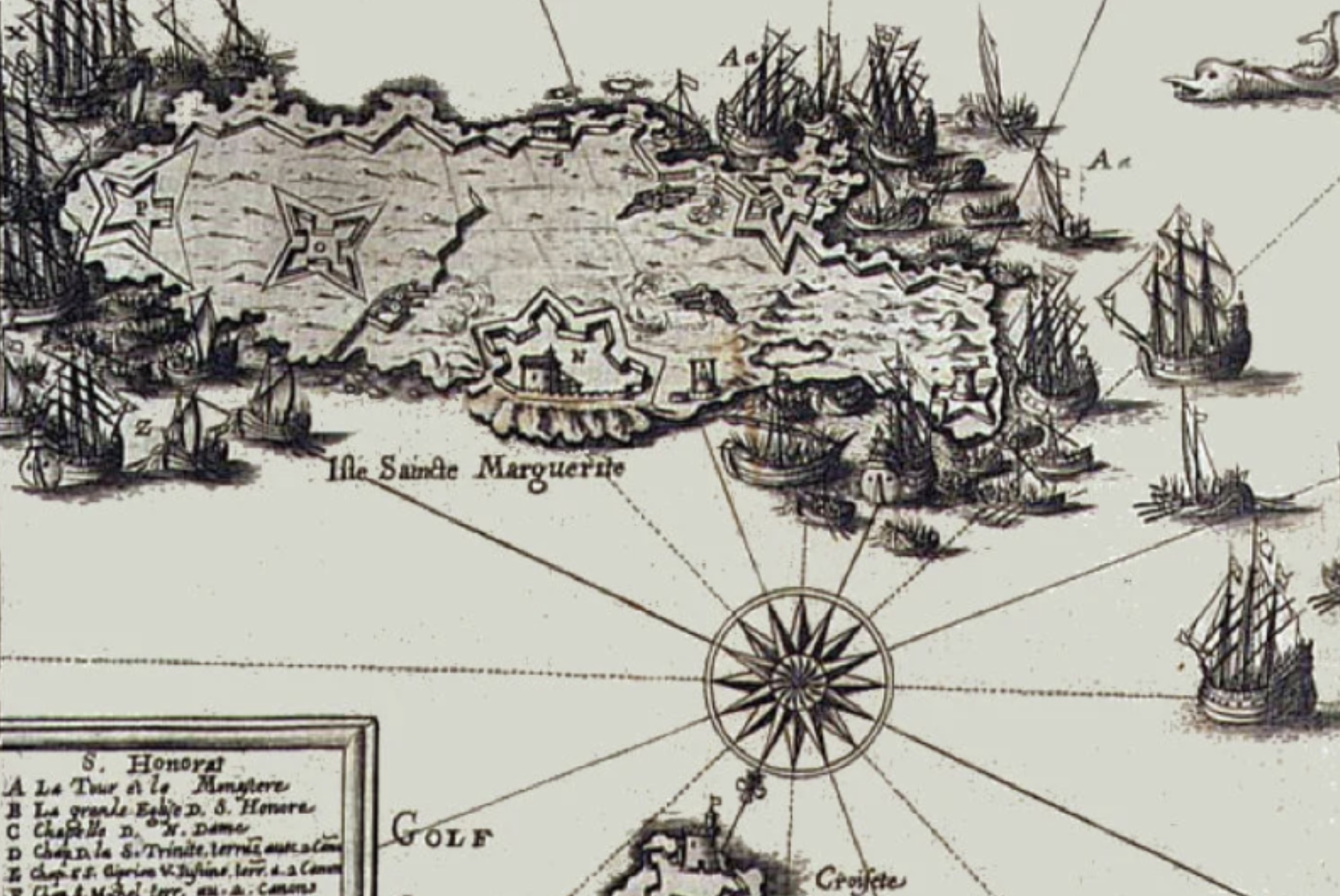
Engraving by Honoré Bouche representing the siege of the Lérins Islands by French troops during the Spanish occupation in 1637
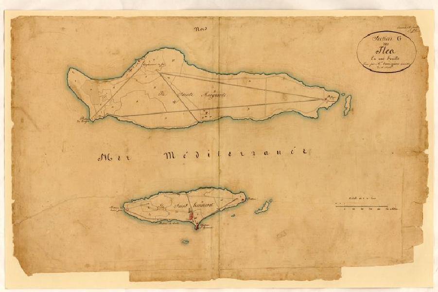
Cadastral map of the islands of Lerins in the 18th century
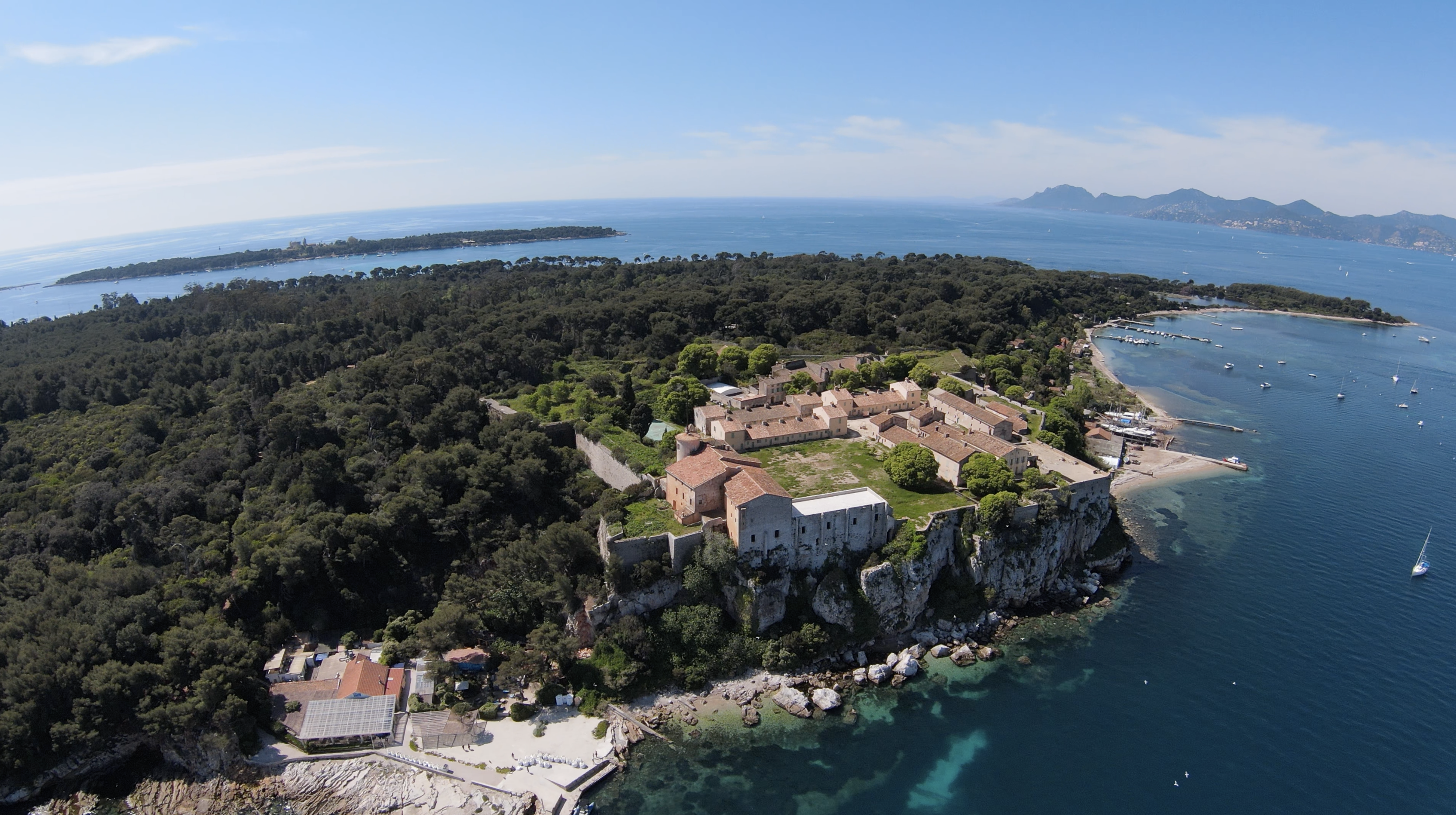
It was not until the beginning of the 20th century that Fort Royal lost its character as a prison, the army then left the island and the site was classified as a historical monument in 1927. In the 1970s, excavations were carried out on and around the islands. The Musée de la Mer opens in 1978 to host their main discoveries. To the north of the island is the Chantier Naval de l'Esterel which welcomes ships up to 45 meters and 250 tons. With a historical and patrimonial dimension, the shipyard opened nearly 80 years ago. The company prides itself on respecting the environment by displaying since 2006 the ISO14001 standard approved by AFNOR.
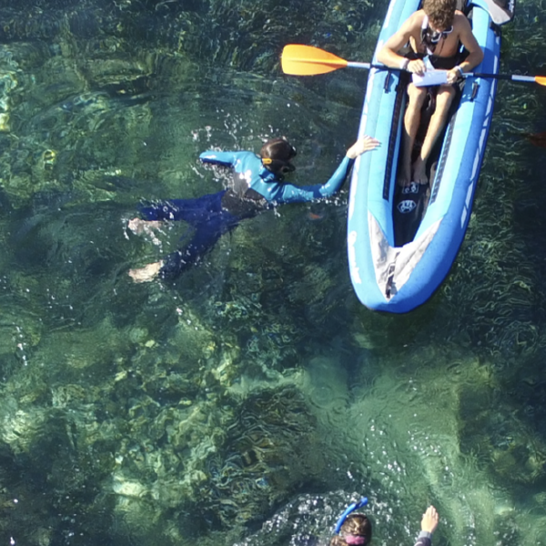
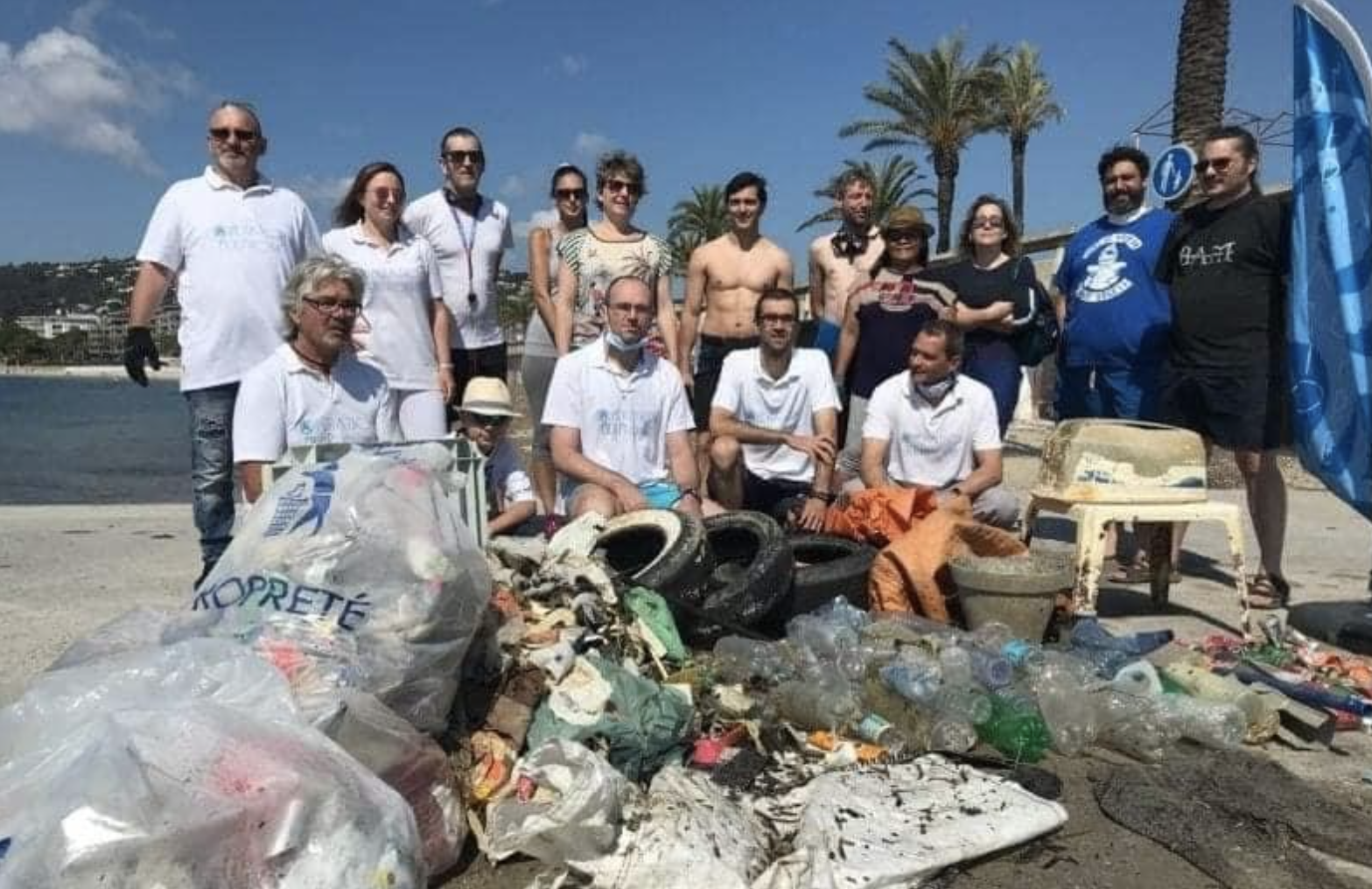
On the scale of the archipelago, macro wastes are collected twice a year by local volunteer divers (Les Amis de Neptune and Gazélec among others). In 2014, the Marine and Alpes-Maritimes Prefectures, the City of Cannes and local companies launched a major cleanup of the northern area of Sainte-Marguerite. 4 shipwrecks, more than 200 dead bodies from 50 kg to one ton, as well as about ten tons of scrap metal were collected. However, there seems to be a lot of stranded boats and fishing nets left on this area according to local divers.
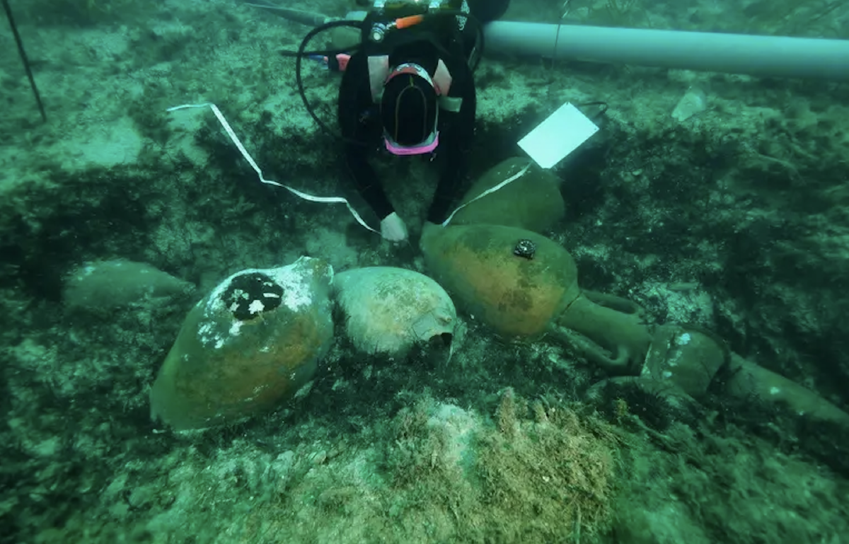
Amphorae were found on a wreck dating from the 3rd century B.C. at a depth of about 20 meters, here in 2019 (M. Langleur)
Cleaning of the seabed by divers
Leader of the socio-educational and sports activities on the island, the Cannes Jeunesse association was established in Sainte-Marguerite in 1971 where it manages the nautical, leisure and accommodation centers. This last one occupies the old barracks of the fort Royal were we stay on the island during our operations at sea. The association welcomes discovery classes of secondary schools, high schools and universities, leisure centers, sports and cultural associations, works councils and other events. It has been awarded the EU Ecolabel by the European Commission, underlining its significant contribution to the improvement of the environment.
The companies Horizon, Trans Cote d'Azur, Riviera Lines and Les Bateaux Verts operate connections with the mainland, mainly from Cannes and with less frequency from Nice, Saint-Tropez, Juan-les-Pins, Golfe Juan, Théoule and La Napoule. The influx of visitors to the island is estimated at between 200 and 600,000 visitors per year, which makes Sainte-Marguerite one of the most visited forests in France. The influx is mainly confined to the western part of the island between the Fort in the North, the pond in the West and the beaches in the South. Note the presence of several snack bars on the island, concessions of the City of Cannes, and of two restaurants: La Guérite and l'Escale, respectively to the East and West of Fort Royal.
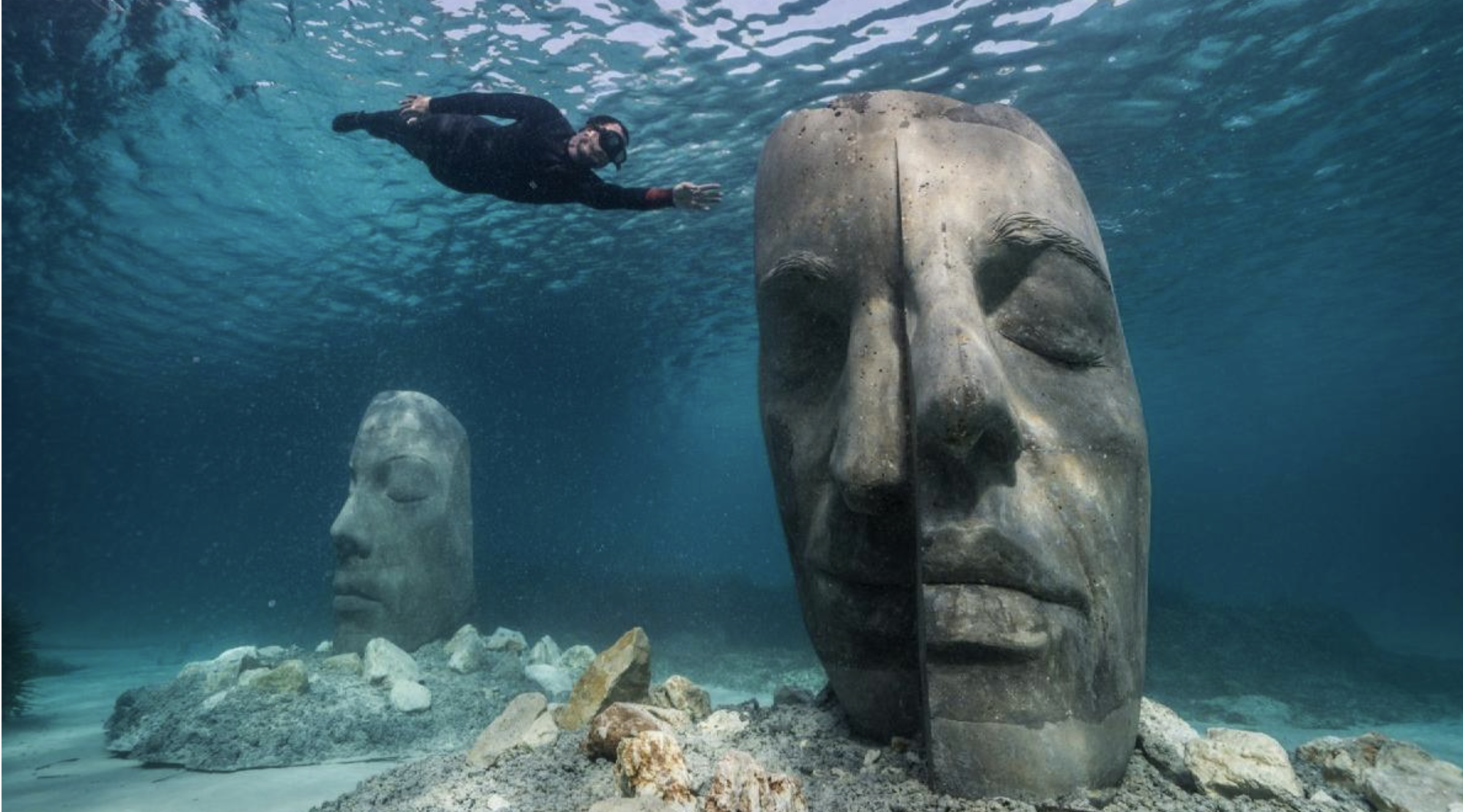
Since 2021, 6 statues of 2m high have been submerged on the South of Sainte-Marguerite as the first underwater eco-museum in France. These monumental statues have been designed to favour the evolution of marine biodiversity.
Ecomuseum area delineated by buoys, on the South of Sainte Marguerite, just off the "Grand Jardin" Villa.
Each statue created by Jason deCaires Taylor is a refuge for underwater species and an artificial reef promoting biodiversity. The rough texture of the statues favours the colonisation of marine fauna and flora, in an area where ships are not allowed to anchor. - Saint Honorat
-
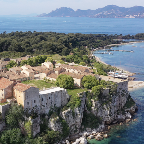
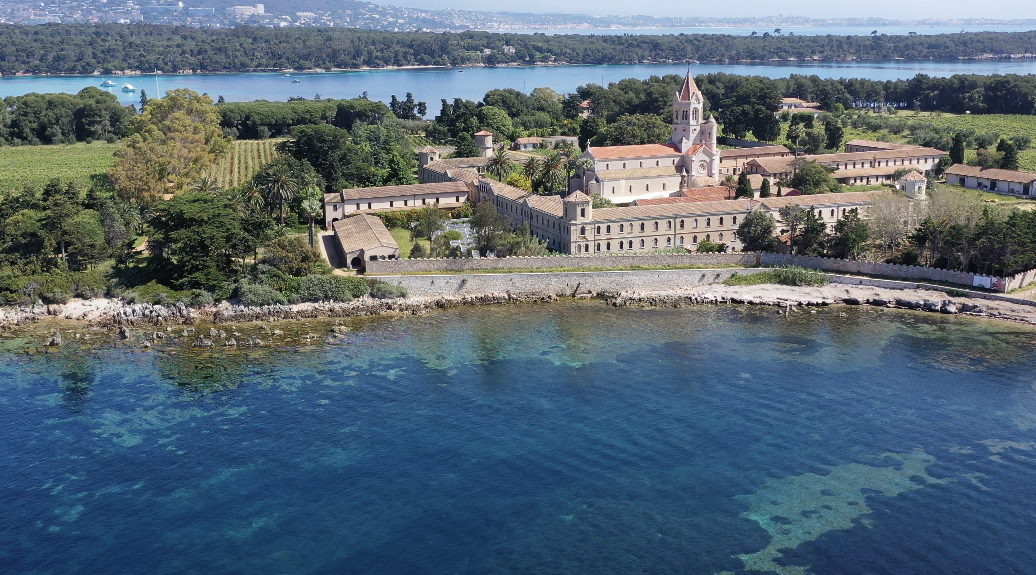
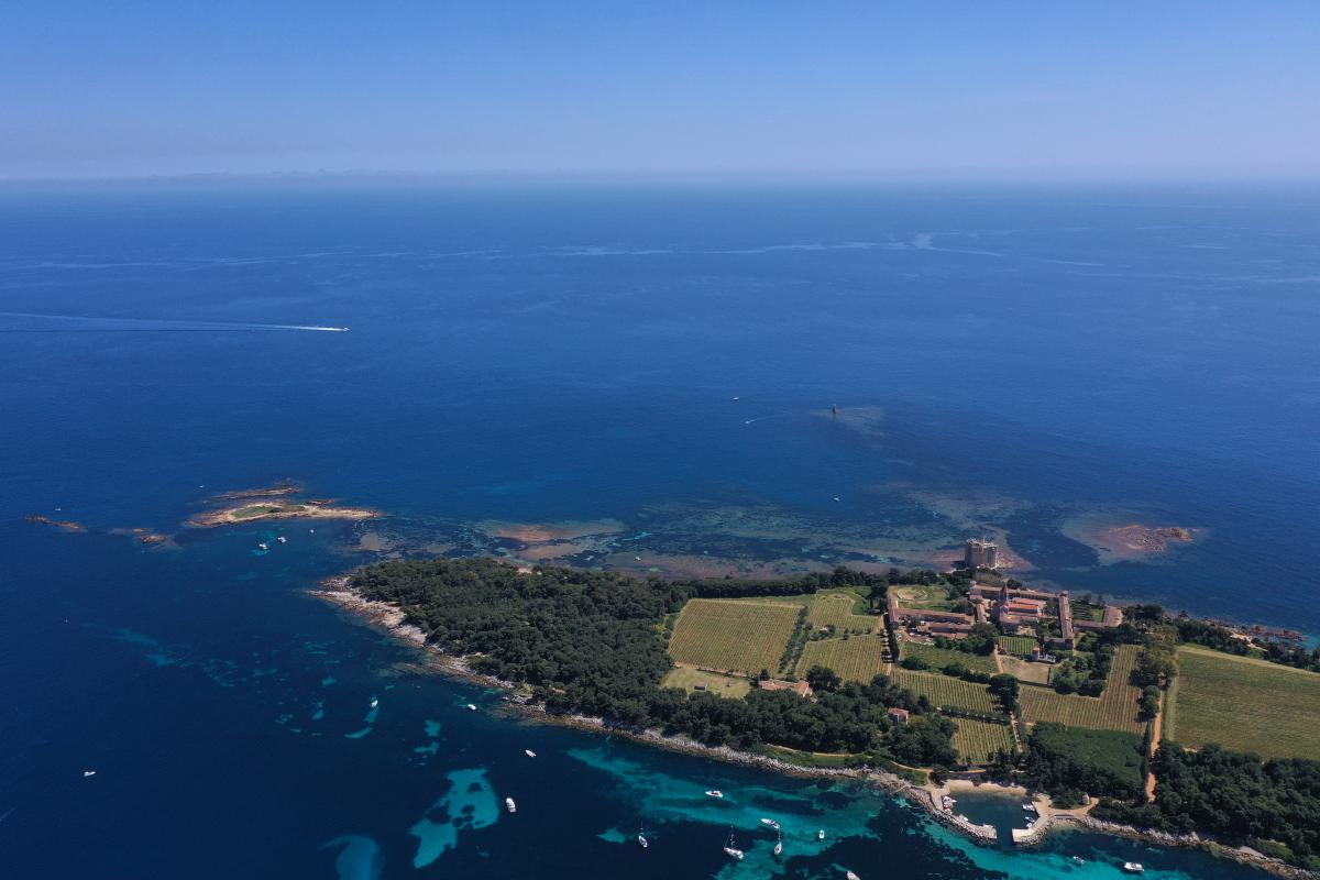
The second island, exclusively inhabited by a monastic community, is only 1.5km long (37Ha). The natural habitats of the island are made up of pine and holm oak forests (on the island) and salt meadows (in the coastal zone). It is named after Honorat d'Arles who founded the island's monastery in the 5th century. The island is accessible to boaters through the Port Abris des Moines to the North (85m of artificial coastline) for a few hours. It is a private property belonging to the Cistercian Congregation of the Immaculate Conception (except for the port and the littoral zone). The site was classified as a historical monument in 1941 (11 years after Sainte Marguerite) thanks to its elements of high heritage value.
The islet of Saint Ferréol and the island of Saint-Honorat, with the monastery, its fortified tower on the background (South), its vineyard and olive trees, and in the foreground the "Port Abris des Moines" (small harbor).
In the extreme south, the fortified tower was built in the 11th century, after many attacks and plunders by barbarians and Saracens, built on ancient foundations. However, the community will continue to go through serious troubles. In the 17th century the Spanish invaded the island, the community even closed in the 18th century, the monastery was sold during the French Revolution to an actress (Mademoiselle Sainval, from the French Comedy) who resided there for 25 years, before returning to worship in the middle of the 19th century.
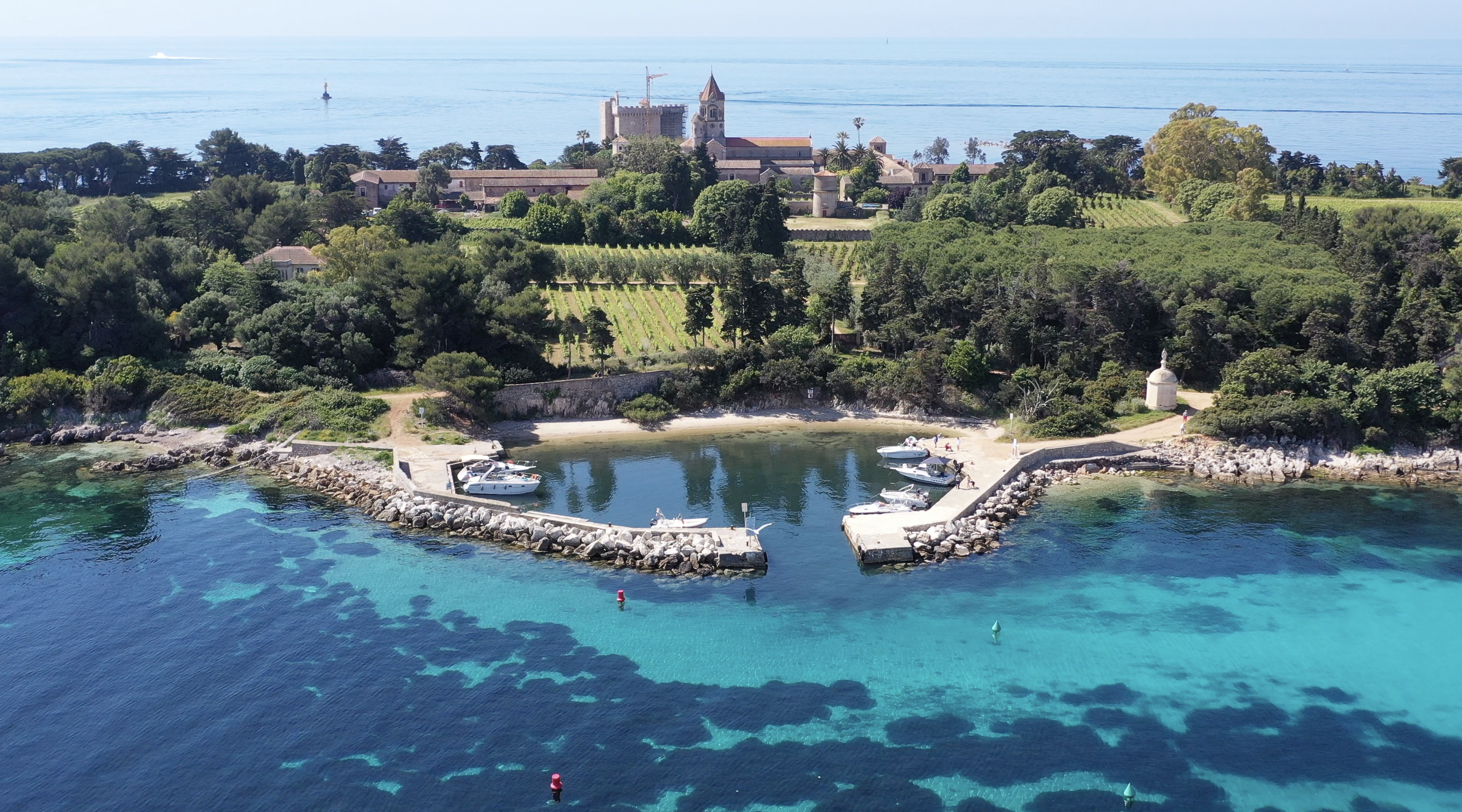
Today, the community is made up of 20 to 25 members. It has been managing 8 hectares of vineyards for commercial purposes since the 1990s (some of the grapes are almost a century old) and produces about 40,000 bottles a year. The monks also offer retreats and spiritual guidance to the public via a hotel offer of more than 10,000 nights per year. The community offers a rather high quality restaurant service during the season and has had a monopoly on shipping to the island and its restaurant since 1988. The Planaria company transports about 70,000 visitors per year on a commercial basis. Finally, the community is involved in the conservation and rehabilitation of the island's heritage (Saint-Sauveur chapel, fortified monastery, more info on projet-lerins.org).
The monastery from the South of Saint-Honorat
The little harbor "Port Abris des Moines", from the North of Saint Honorat. - Le canal du Frioul
-
The two islands are separated by chenal also called Le Canal du Milieu of 700 to 900m wide and less than 10m deep. Studies suggest that this separation dates from a violent earthquake in the 4th or 5th century AD.
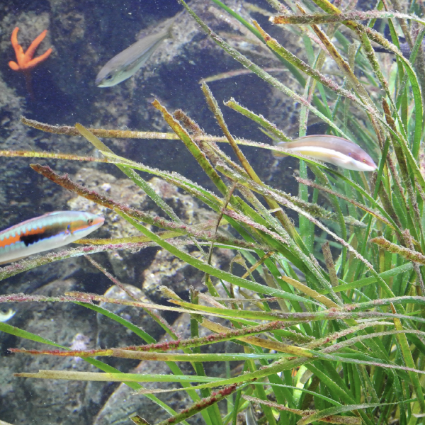
The seabed is dominated by an alternation of fine sand dunes and posidonia, which suffers from the strong influx of boaters during the summer (up to 500 boats in one day). An organized mooring system (fixed) is under study. At the same time, Andromeda Oceanology has created the Donia application, which allows users to position themselves at sea in relation to the nature of the bottom and thus anchor outside the Posidonia meadows. Most of the macro-waste observed around the islands is located in this area.Le canal du Frioul (or Canal du Milieu), seen from the east of the archipelago, with Sainte Marguerite on the right, Saint Honorat on the left, the sand dune in the middle, and the Esterel mountain range in the background. - The islets
-
The two main islands are accompanied in their East by an islet each one which do not offer any easy means of accosting. The vegetation and fauna are not very developed. La Tradelière, to the east of Sainte-Marguerite, is covered with Mediterranean halophilic thickets (Salicorne, Obione faux pourpier) and halo-nitrophilic thickets sheltering the European Phyllodactyl, a reptile of the gecko family, protected and with a high conservation stake. Saint-Ferréol, to the east of Saint Honorat, is covered with halo-nitrophilous thickets.
The Saint-Ferréol islet, with Saint-Honorat in the background. The "ïlot" is to be seen between both (rocks surfacing on the left of the picture).Finally, it should be noted that karstic formations outcrop a few hundred meters south of Saint-Honorat, forming a reef sometimes called "l'îlot". This formation extends in subsurface until the beacon of the Monks (700m from the fortified tower), materializing the danger created by this shoal.

The physical setting
- Geomorphology
-
The archipelago is located between the bays of Cannes and Golfe-Juan, at a minimum distance of less than one kilometer from the mainland (between the Pointe Croisette in Cannes and Sainte-Marguerite). The whole area represents approximately 2,5 km2.
The islands are called "continental" because they are fully part of the eponymous plateau from which they were isolated during the last marine transgression about 10,000 years ago. Moreover, the marine part between Cap Croisette, Sainte-Marguerite, Saint-Honorat and the beacon Les Moines at the extreme South of the archipelago offer depths rarely exceeding 5 to 10m. The islands themselves show a very flat topography, generally lower than 10m high, except for the hillock on which the Fort Royal was built on Sainte-Marguerite (about 25m high).
On the islands, the coastline is mainly rocky of limestone type, with some areas of loose substrates of pebble to mud type. More particularly, the subsoil is composed of dolomite from the Liassic period (Jurassic, 175-200 million years). This rock is very compact and impermeable and often covered by a red clay silt on a thickness of about 20 cm. The beaches are reduced, mainly in the North East and South of Sainte-Marguerite.
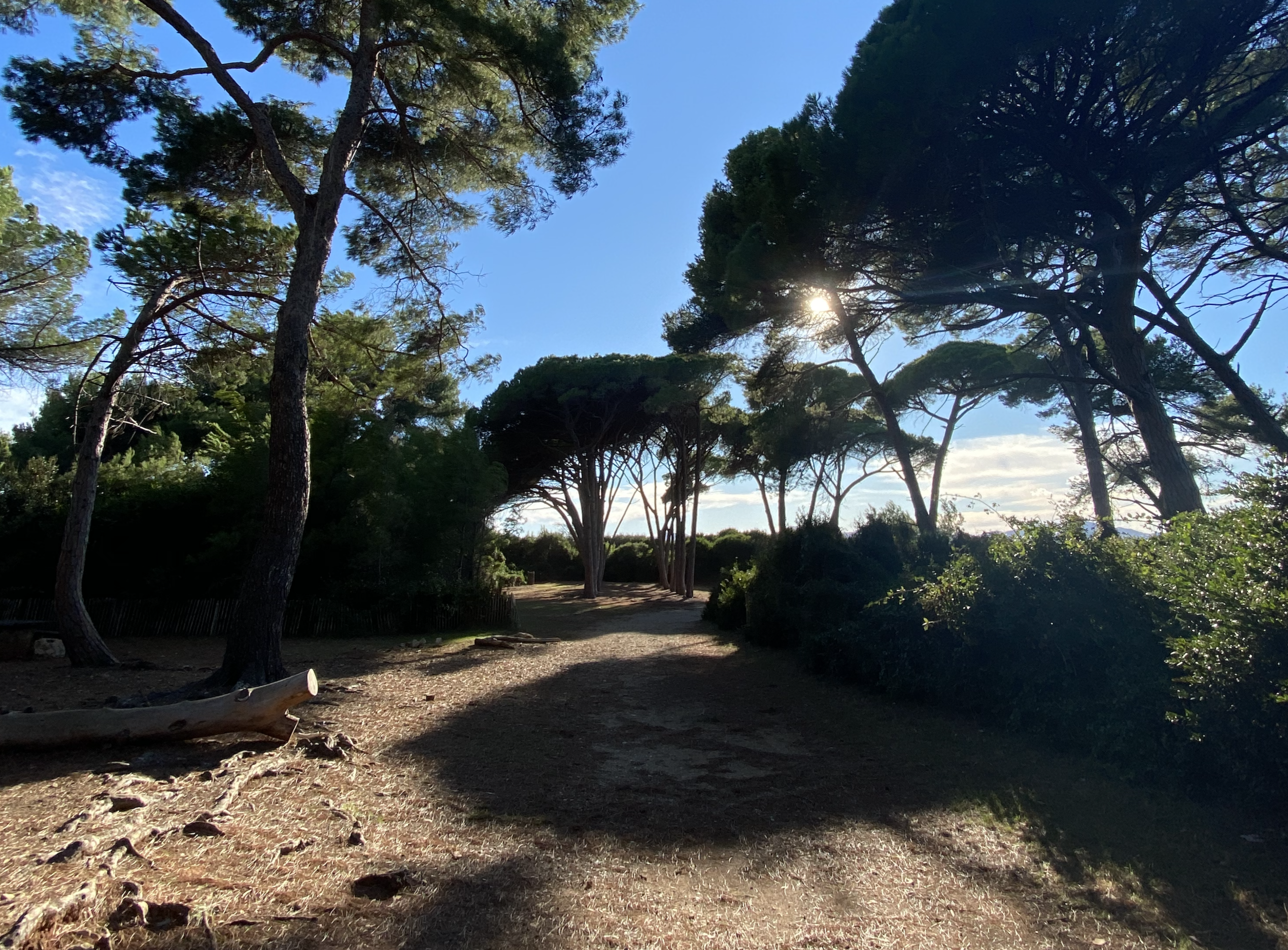
Path on the South of Sainte-Marguerite
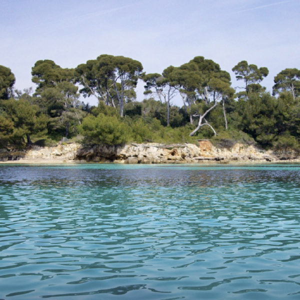
South West of Sainte Marguerite from Pointe du Dragon - Currents
-
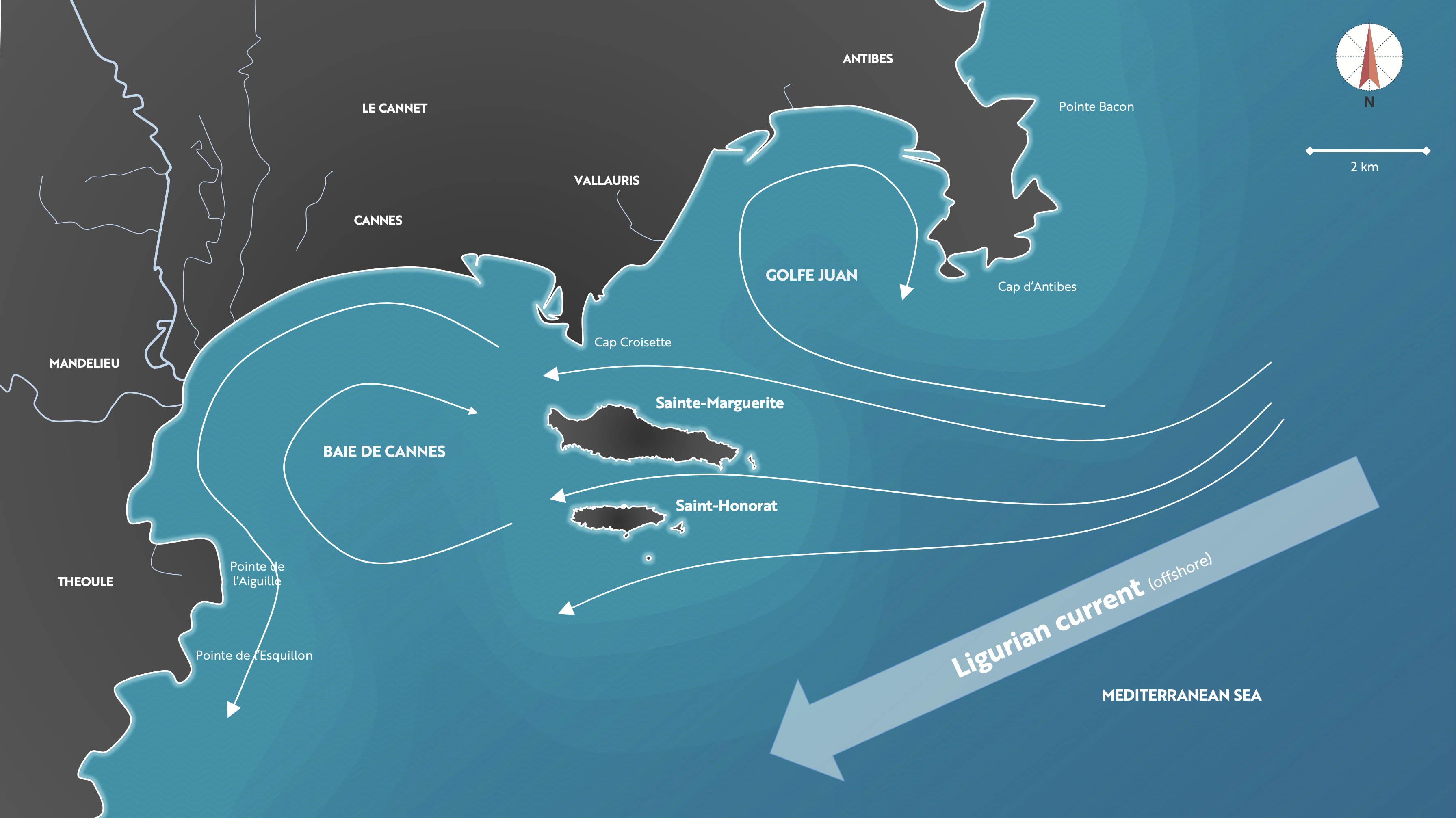
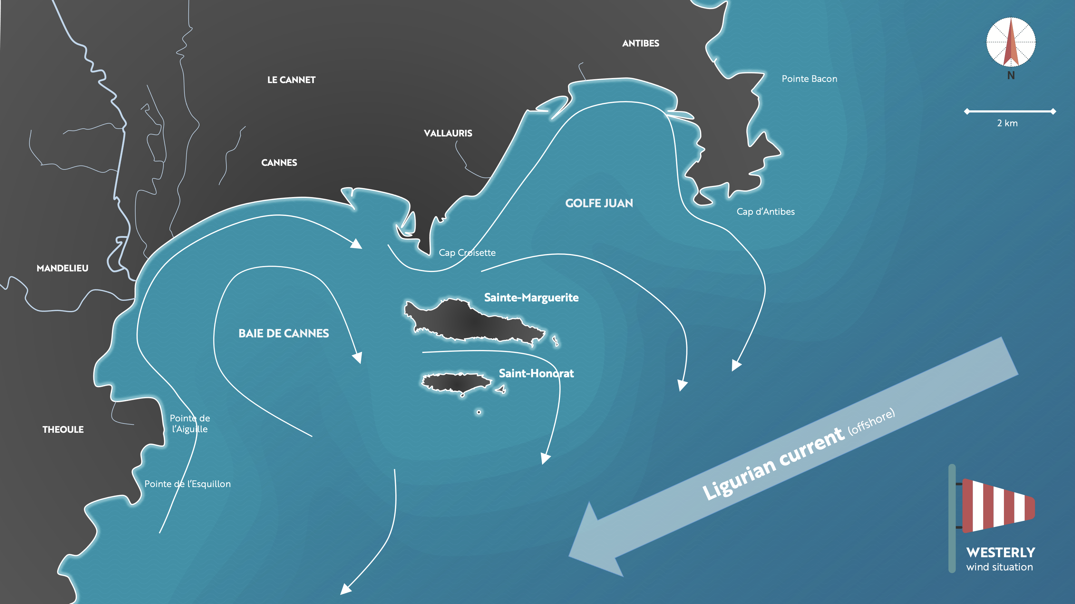
The whole North-Western Mediterranean (roughly from Spain to Italy) is influenced by a major East-West current called the Liguro-Provençal current, with a speed ranging from 25 to 50cm/s. This current rises from the South of Italy where it is formed from several flows coming from the South (Algerian basin) and from the East (Tyrrhenian Sea). It passes about 20 miles (30 to 40km) from our coasts, where it is more particularly called Ligurian current.
Thus, most of the time, the current is East-West between the Cap d'Antibes and the Pointe de la Croisette. This scheme represents only an ideal situation, which can be modified by the wind regime and the exchange of water masses between the bays of Cannes and Golfe-Juan. The archipelago itself creates an obstacle to the Ligurian current, a part of which goes up towards Golfe-Juan by creating an anticyclonic circulation. The strong East winds generally reinforce this ideal situation by creating a global East-West circulation around the islands, while a strong West wind will be able to disturb the situation by directing the current of the archipelago towards the East.
General westward current pattern
Particular current pattern in case of strong Westerly winds - Climate
-
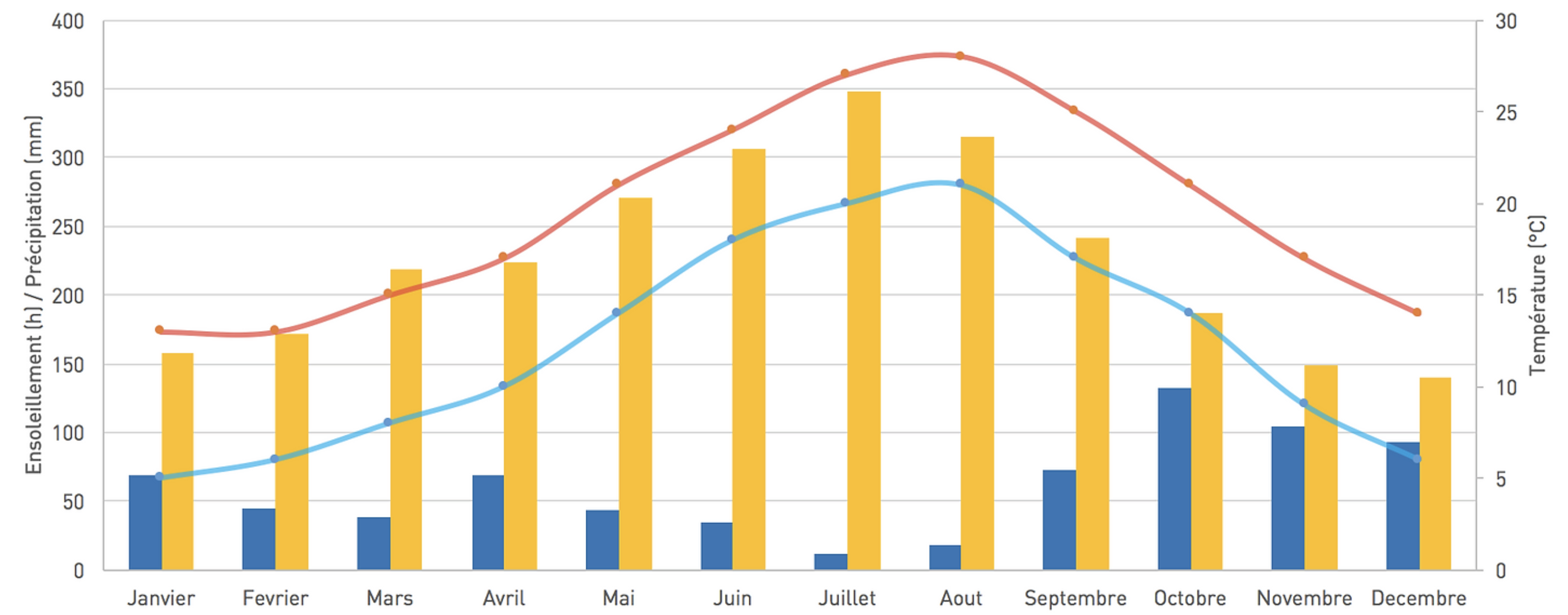
It is obviously the maritime Mediterranean climate that bathes the archipelago, dominated by long, hot and rainless summers, punctuated by a few days of sirocco. Heavy rains fall in spring and autumn and frosts are rare and moderate. A great luminosity bathes the whole, helped by numerous gales. The night air is full of humidity coming from the sea. Climate and soil allow to predict the evolution of the typical vegetation of the island, whose forest of Aleppo pines and holm oaks is the climax.
Main climatic elements on the Iles de Lerins - Hydrology
-
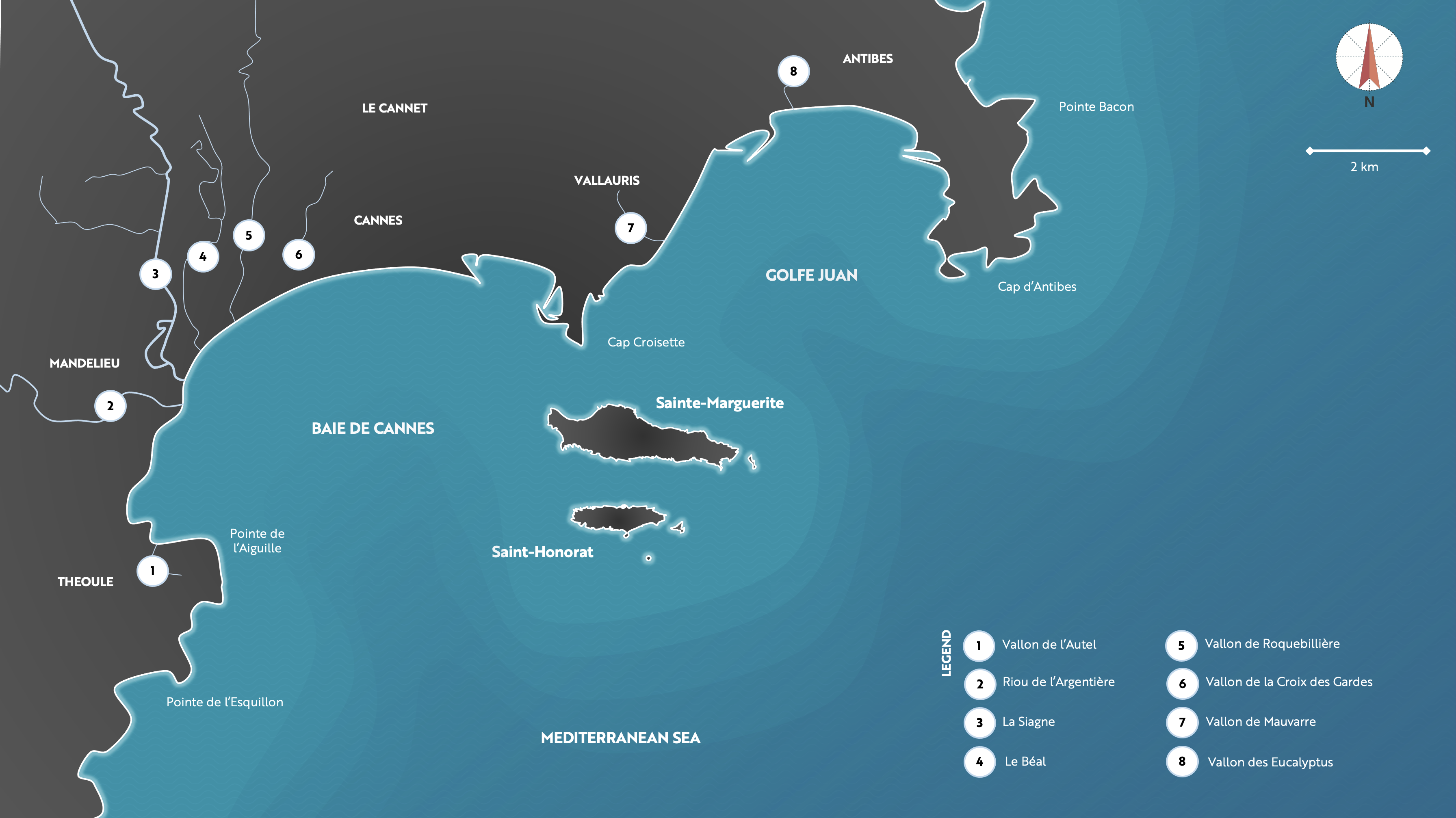
Among the rivers flowing into the Bay of Cannes, Siagne has the most important flow (about 9m3/s at Pégomas, north of Cannes). With a length of about 45km, it crosses Auribeau-sur-Siagne, La Roquette-sur-Siagne and Mandelieu-la-Napoule where it is transformed into a marina. It supplies the cities of Grasse and Cannes with water thanks to the Siagne canal. The Riou de l'Argentière also flows into Mandelieu after having travelled 15km from Fréjus. Finally, let us note several small streams with reduced flow, some of them derived from the Siagne such as the Béal which used to feed an old mill.
Main rivers flowing to the Baie de Cannes and Golfe JuanOnly a few streams with very small flows and catchment areas flow into the Golfe Juan, such as the Mauvarre and Eucalyptus valleys. To the east of Cap d'Antibes, other rivers can have an influence on the archipelago because of their flow and/or possible pollution, such as the Brague (Antibes), the Loup (Villeneuve-Loubet) and the Var (50m3/s at Nice / Saint-Laurent du Var).
There are no watercourses as such on the islands. The Etang du Bateguier (4Ha) is fed by precipitation and by the sea from passes located in the North and in the South. Several springs have been identified, but all are below sea level. They can lead to desalination and very local modifications of the marine ecosystem. These springs are the result of infiltrations on the karstic plateaus of Caussols and Gréolière. The most important resurgence is located south of the fortified monastery of Saint Honorat at a depth of 5m (source La Boutte, estimated at 200L/s).
With no fresh water source on the archipelago, the drinking water supply comes from the mainland through a pipe established in 1930 between Cannes and Sainte-Marguerite and later to Saint-Honorat. Note: the only well formerly used on Saint-Honorat is considered non-drinkable (brackish).
The human context
- Urbanization of the archipelago
-
The islands are home to a very small year-round population. Saint-Honorat is home to about twenty monks. On Sainte Marguerite, Fort Royal only welcomes the public on a short-term basis and the cabins in the "village" are rented out for the summer season (see "The islands and their history").
The coastline of the archipelago is very little urbanized, with 240m of artificial coastline on Sainte-Marguerite at the level of the shipyard (Chantier naval de l'Esterel) and 90m on Saint-Honorat at the level of the Port-Abris. The port area to the north-west of Sainte-Marguerite does not have an artificial coastline.View of the village, at the North-West of Sainte-Marguerite - Tourism, beaches and yachting
-
The Côte d'Azur is the most popular touristic destination worldwide, welcoming more than 10 million tourists per year, thanks to approximately 150,000 accommodation places. A quarter of them arrive at Nice airport, the second largest in France. The Paris-Nice line alone accounts for more than 3 million travelers per year. Communities like Cannes and Antibes can more than triple their traffic in summer. This increase can have ecological impacts through the construction of infrastructures and the over-frequentation of natural areas. But one of the main challenges remains the waste water, which has not always been properly treated before being discharged into the sea.
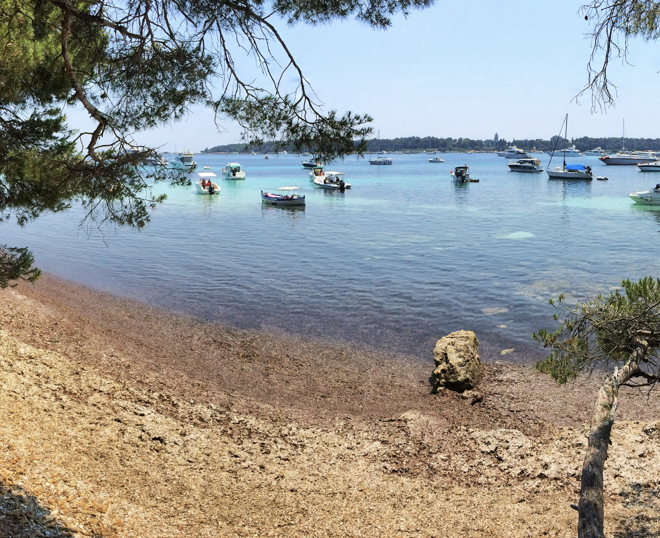
Beach on the South of Sainte-Marguerite, view in Spring on the Canal du Frioul and Saint-Honorat on the background.View of the archipelago in summer, with the numerous boats in the Canal du Frioul (Saint Honorat on the foreground)
The Cannes-Antibes area is one of the three largest yachting areas in the PACA region, with 60% of the department's workforce. It is therefore not surprising to count nearly 9,000 places in the twenty or so ports surrounding the archipelago. The main mooring area is undoubtedly the Frioul Canal, with up to 1,000 boats per day during the summer months[1]. More and more large structures (over 30m and 50m) are being observed. It should be noted that no non-invasive mooring is installed in the area.
On a large part of the archipelago, the coasts are rocky and jagged, creating reefs, cliffs and small creeks. The beaches are therefore rare and reduced, the largest being located in the northwest and south of Sainte-Marguerite. Theoretically, the beaches of the archipelago do not undergo any development or mechanical cleaning, the sea leashes are preserved during the winter and there is no sand replenishment [2].
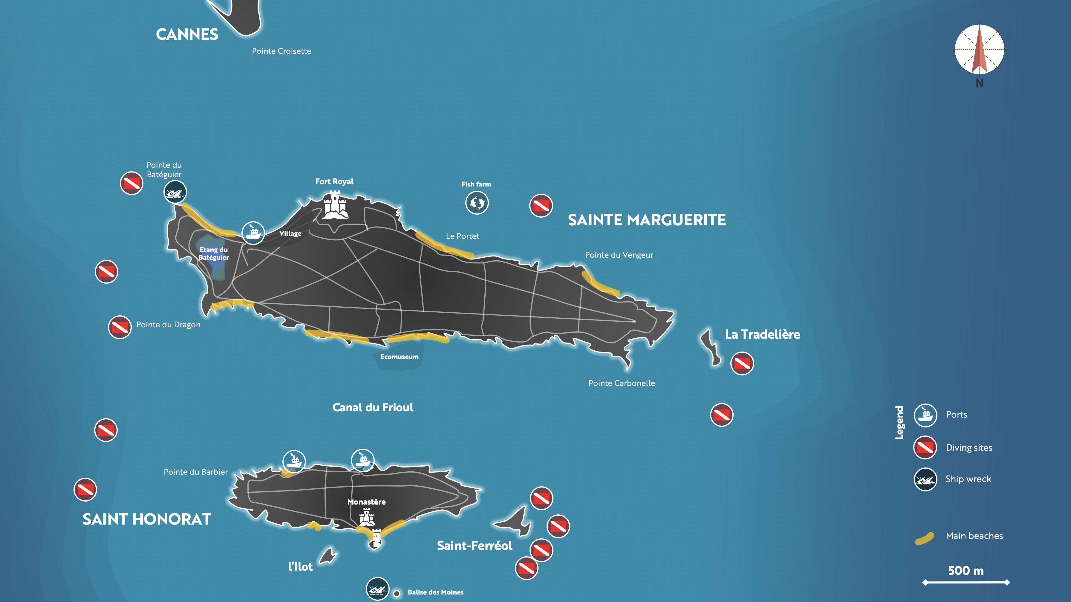
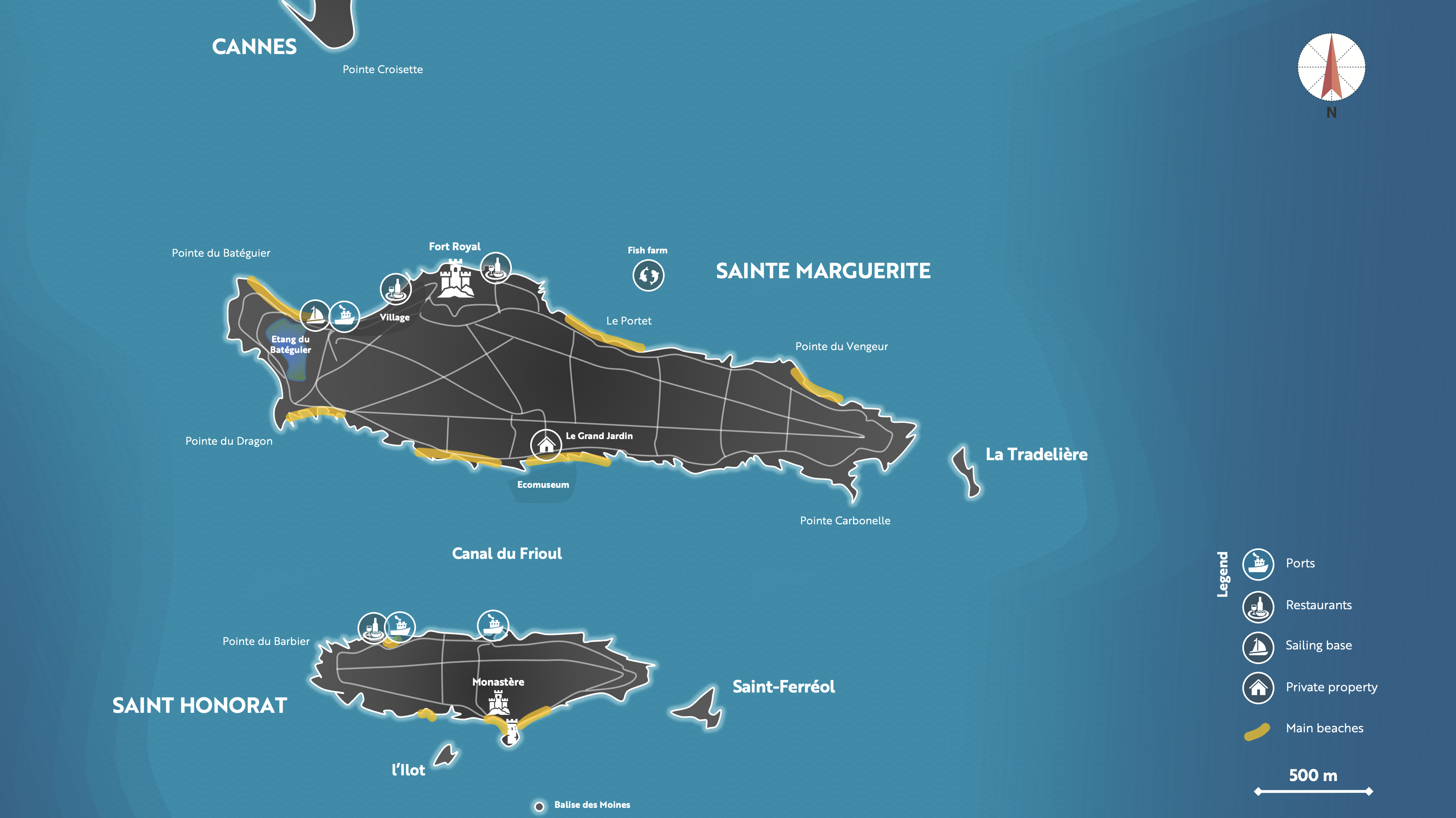
Main sites of attraction on and around the islands (diving sites, ship wrecks, ecomuseum, monastry, Fort, village, beaches).[1] Comité de Pilotage du site Natura 2000 (K. Joyaux, 2011), CPIE 2005
[2] Comité de Pilotage du site Natura 2000 (K. Joyaux, 2011)
- Wastewater and stormwater treatment
-
Local authorities have invested heavily over the last decade to renew the wastewater treatment plants.
Nobilis, in Golfe Juan, was commissioned in 2008 to increase its capacity from 50 to 65kPE (thousands of population equivalent). Its outfall discharges the treated water into the Gulf of Juan, nearly 2km from the coast and 40m deep. It is monitored by the CSIL (Centre Scientifique des Iles de Lérins) since its opening. During strong rainy episodes, direct discharges are possible very punctually to avoid the flooding of the station. There is no treatment of rainwater which is therefore discharged directly into the sea through the outfall of the old plant behind the port Camille Rayon.
In Cannes, Aquaviva replaces since 2012 the old Cannes wastewater treatment plant which was no longer able to treat the volume of wastewater created by the influx of summer tourists. It can now treat 300kPE (230kPE before), which has drastically reduced the discharges of organic matter and suspended matter recorded before 2012. The two plants are managed by Suez Environnement under a public service delegation contract awarded by the Syndicat intercommunal unifié d'assainissement du bassin cannois (SIUABC) since 2006. - The measures put in place
-
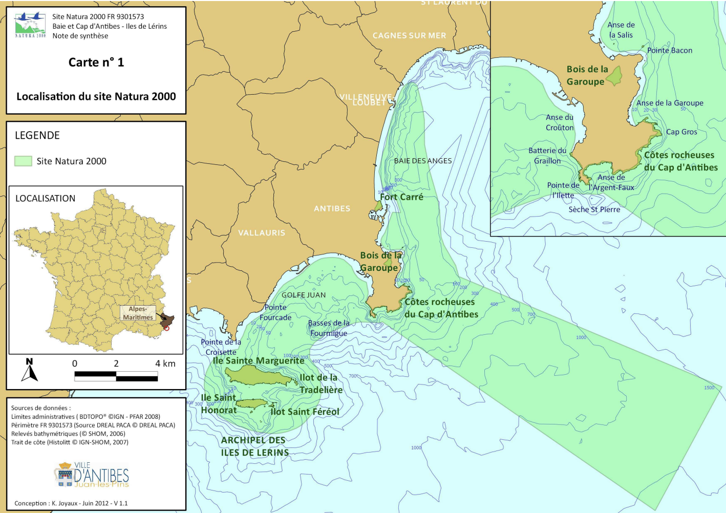
The area is part of the European Natura 2000 program, whose objective is the conservation of fauna, flora and various natural habitats considered valuable. If this label is not very restrictive as to the new measures to be implemented, its main interest is that it frames any new construction or degradation (example of pharaonic projects in the 19th century below). Locally, this program regulates, for example, the anchoring areas in order to avoid the degradation of natural habitats.
Extend of the Natura 2000 site around Iles de Lerins
Agenda 21 is a global program adopted by 178 countries at the World Environment Summit in Rio de Janeiro in 1992. Its objective for the city of Cannes is to improve the quality of life, preserve the natural environment and promote sustainable development. The implementation of a new wastewater treatment plant in 2012 was one of the fruits of this program.
It should also be noted that the archipelago is part of the RAMOGE area (an international structure that pilots the maritime zones of the Provence-Alpes-Côte d'Azur, the Principality of Monaco and the Liguria Region) and the PELAGOS sanctuary (Agreement between Italy, Monaco and France for the protection of marine mammals.
The elaboration of these programs required a long preparation, numerous studies and discussions. Many local actors participated, such as the Agency for Marine Protected Areas, the Water Agency, the ONF, the Regional Council, cities, local associations and research departments. It should be noted that if the fight against large-scale marine pollution is organized on a departmental scale (Polmar Sea plan), the cities of Cannes and Antibes have their own Infra Polmar plan and have their own equipment to treat potential pollution in the area.