


Groundwater detection and sustainable aquifer management in Cameroon
Exploration and sustainable management of water reservoirs: Quantifying the impact of climate change on water reserves through the installation of weather stations and humidity sensors.
Academy Highlight
“Environmental challenges related to water exploration” and its sustainable management are at the center of this project, which focuses on local monitoring by meteorological stations to quantify climate change and its impact on water reserves.
The project
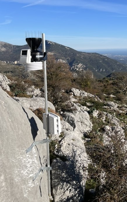
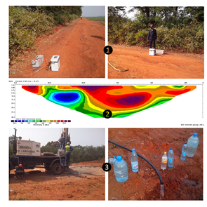
This project aims to continue underground exploration to monitor the aquifers and has identified three main avenues to be explored: 1) a scientific component to improve the processing of available data in conjunction with AEP, and the new Saba (Sanaga Basin Aquifers) and Granite (Groundwater Targets) projects at the University of Yaoundé, in addition to selecting exploration sites with the possibility of deploying weather stations and soil moisture sensors on site to quantify the impact of climate change on groundwater; 2) a socioeconomic component to protect, exploit and sustainably manage this precious resource; and 3) an educational component (Edu-Delo). The aim of the Edu-Delo project is to create a “test site” observatory. We want to develop an educational project in hydrology, by creating a network of sensors connected to a database, from a few months to a few years, depending on the objectives. The use of three weather stations combined with groundwater pressure sensors could be the first step in creating a permanent hydrological network.
The station's network of sensors could estimate the amount of water that infiltrates during periods of rain and the evapotranspiration on that surface. Support for this equipment as a school project gives a strong partnership dimension to this hypothetical network and creates a synergy of interests. The project not only has a research dimension, but also an ambitious educational component based on teachers identified before the installation. Hydrology will be addressed in school through themes related to the management of primary resources.
Water management is, of course, the main focus of the project. Linked to specific meteorological events, but also to longer-term climatic trends, its study should allow more or less broad themes to emerge. The monitoring of groundwater through its return to the surface (of interest for the installation of Reefnet-type water level sensors in the absence of existing data) or its storage (by geophysical imaging) may be an ambitious first area of research currently funded in the region.
The database developed would be managed by local university staff. Following the example of EduMed-Obs at Geoazur, we will create an open “data center” and use existing tools to provide easy access to the data. The main mission of the project will be to increase the visibility and outreach of the research team's work in hydrogeological observation, and disseminate it to the public (science and citizens) and especially to schoolchildren (science and research).
The +
The Edu-Delo project addresses several issues:
1) The environmental challenge of data processing for groundwater exploration and sustainable management;
2) Local monitoring through meteorological stations to quantify climate change and its impact on groundwater resources; and
3) "Educational" actions following the example of EduMed-Obs of Geoazur to involve students and civil society.
What's next ?
This project plans to create educational material about hydrology, an observatory, and a hydrogeological database. The Edu-Delo educational component and the interface providing easy access to research and educational data on sustainable water management will be implemented in 2024-2025. To support its actions in the longer term, the project is expected to strengthen partnerships with regional authorities involved in water management.
Project informations
| Scientific field: Earth Sciences Hydrology |
Keywords: Electrical data Education Weather stations groundwater monitoring sustainable management |
| Partner laboratory:
|
Budget: €10,000, including €5,000 from Academy 3 |
| Project members: Alessandra Ribodetti Julien Balestra Fabrice Jouffray Benoit Viguier Lionel Mbida Yem Clémence Audrey Emaha Tcheendjam Léandre Onana Emana |
Students involved: Mohamed Moustapha Njikam Edwige Ogadiga |
Alessandra Ribodetti
Géoazur – Université Côte d’Azur, CNRS, OCA, IRD
Lionel Mbida Yem
University of Yaoundé 1
Scientific promotion of the project
2024: Mbida Lionel, A. Ribodetti T., Lebourg J. Q. Yéné Atangana,Jenny Trevisan, P.D. Ndjigui Abdelaziz Mridekh, Hydrogeological systems and sub-outcrop aquifers of the Sanaga buttes and alluvial terranes fault zones: New insight from Resistivity images, cutting samples and outcrops data, Geosystems and Geoenvironment, en révision
2023 : Ndam Njikam M.M., Mbida Yem L., Ribodetti A., Mohamed A., Soumah A., Junior M.P., Alarifi S.S., Abdelrady A. (2023). Application of the electrical resistivity method and the estimation of limestone volume: a case study. Frontiers in Earth Science, 11, 1280414 [13 p.]. ISSN 2296-6463. Identifiant IRD: fdi:010089124
2023: Diallo S., Njikam M. M. N., Yem M., Atangana J. Q. Y., Ribodetti A., Raouf A. (2023). Integration of magnetic and geological field data into geological mapping and rutile mineralization targets in the Minta locality (Haute-Sanaga, Cameroon). Exploration Geophysics, [Early access], p. [15 p.]. ISSN 0812-3985.Identifiant IRD: fdi:010087685
2023: Ndam Njikam Mohamed Moustapha, Mbida Yem, Meying Arsène, Alessandra Ribodetti, Messi, Gabriel, Chiewo Ceukou Tethys-Authie, Jean Maoro Zoumanigui, Combined analysis of resistivity and IP tomography for 3D modeling and preliminary volume estimation of the possible gold mineralization zones in the Simi locality, Adamawa, Cameroon, Geophysical Prospecting, March 2023, https://doi.org/10.1111/1365-2478.13343
2023: Njikam M. M. N., Mbida Yem L.., Meying A., Ribodetti A., Messi G., Tethys-Authie C. C., Zoumanigui J. M. (2023). Combined analysis of resistivity and induced polarization tomography for 3D modelling and preliminary volume estimation of the possible gold mineralization zones in the Simi locality, Adamawa, Cameroon. Geophysical Prospecting, [Early access], p. [16 p.]. ISSN 0016-8025.Identifiant IRD: fdi:010087502
2021: E. M.-F. Mienlam, L. Mbida, J. Q. Y. Atangana, P. Nguema, A. Ribodetti. Stratigraphical nature and Palaeogeographical significance of the Top Albian surface in the South Cameroon Atlantic Margin. EAGE, DOI: 10.3997/2214-4609.202112834
2021: L. Mbida, J. Q. Y. Atangana, P. Nguema, A. Ribodetti. Seismic stratigraphy and deep structure of the Kribi basin (Cameroon Atlantic Margin); EAGE, DOI: https://doi.org/10.3997/2214-4609.202011949
2017: Mbida L., J.Q.Y. Atangana, P. Nguema and A. Ribodetti, The Kribi-Batanga Jurassic-Cretaceaous Fan-delta System, EAGE, Petroleum Systems of Sub-Saharan Africa, 2017, DOI: https://doi.org/10.3997/2214-4609.201700929