


Floods and Other extreme Rain Events in South-East France and Italy
Extreme rainfall events are increasing in frequency and require new approaches to mitigate and manage their devastating impacts
Academy 3 highlight
Foresee addresses large scale flooding, “a natural hazard that impacts the environment” and an increasing number of cities and societies throughout the world as rainfall events grow in intensity and as a greater number of the world’s people settle in alluvial plains exposed to floods.
The project
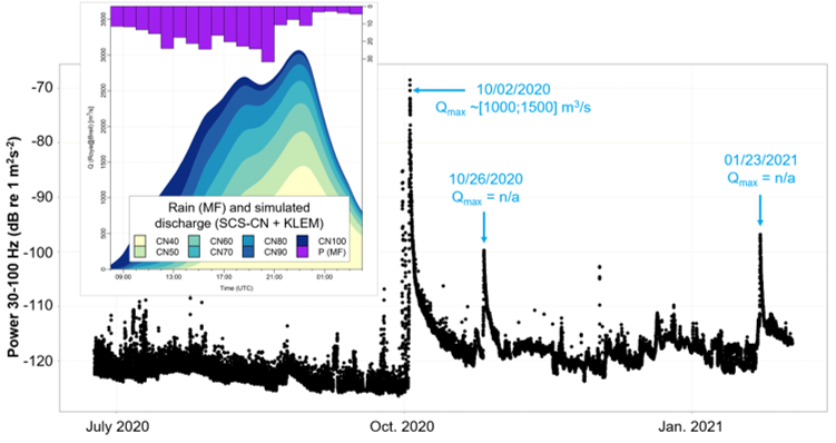
Deadly storms struck south-east France in 2015 and again in 2020 causing close to 40 cumulative fatalities and several hundred million euros in damage. The 2015 event hit the urbanized coastal catchments of Cannes and Biot, while the 2020 event, greater in magnitude, occurred in the Alpine valleys of the Vésubie and the Roya. Both events generated historic rainfall depths and discharges. The objective of the Foresee project is to identify lessons that could be learned from these major events in order to better manage extreme rainfall events in the future.
The project addresses four main themes: 1) the vulnerability of linear networks; 2) the human response to extremes; 3) landscape changes; and 4) urbanization and flood risk.
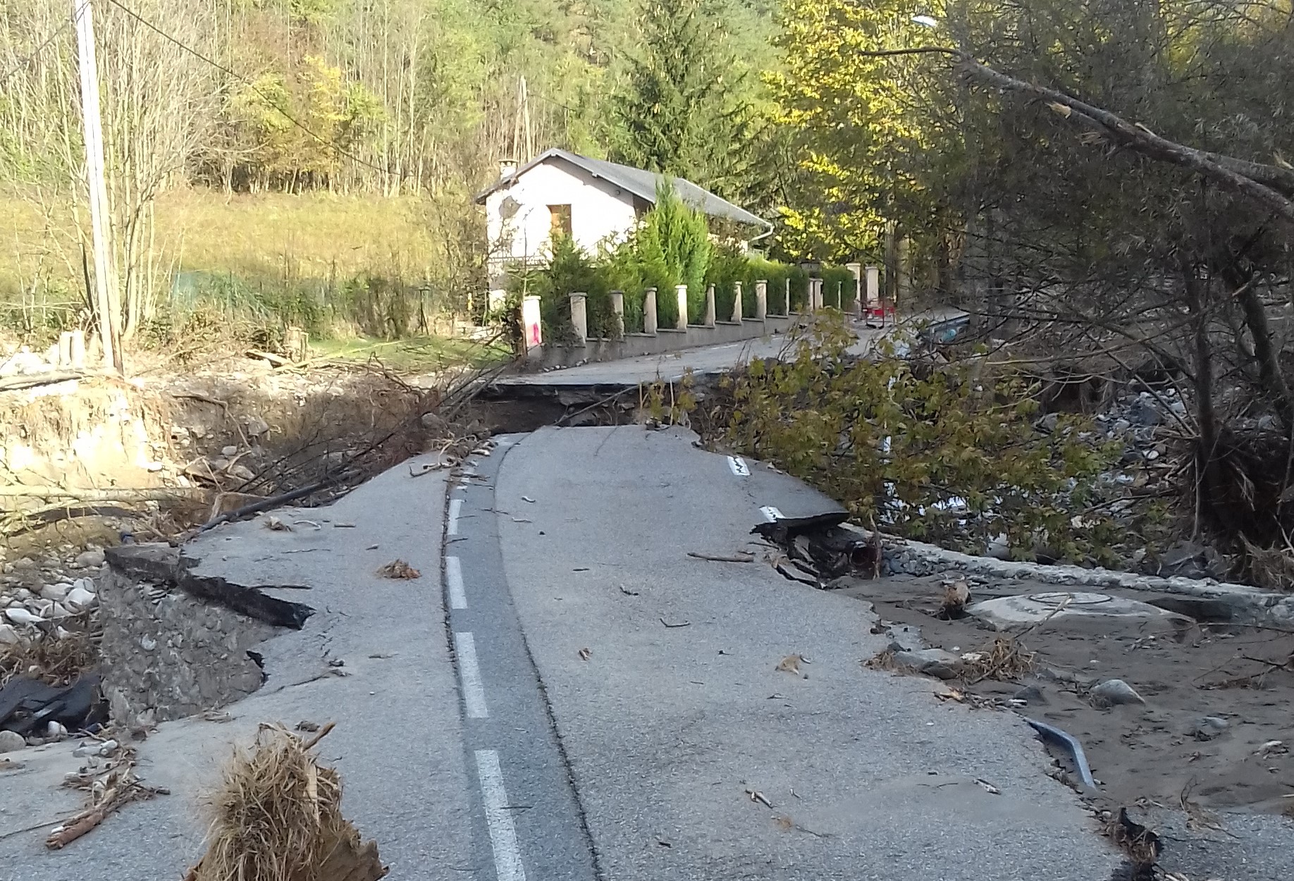
Electrical and communication lines are buried under roads, so when a road is damaged by bank erosion or a landslide, power and communication are automatically cut. Similarly, these services are concentrated at focal points on bridges, which means that a bridge rupture inevitably cuts power and communication, including to transmitter pylons, putting even cell phones out of service. A first step in improving post-event resilience is to identify vulnerable sections of the road (for example, alluvial deposits close to the channel or meander convexities, or steep thalwegs prone to mass movements intersecting the road network) and plan for alternative routes. These measures include the upkeep of secondary dirt roads and train routes and maintenance of electrical generators and emergency communication devices in mountain municipalities to ensure better preparedness. Perhaps most importantly, smaller isolated hamlets and families need to be trained in disaster preparedness, so they can be self-sufficient for at least three days (food, water, medicine, heating, etc.) while waiting for rescue workers to arrive.
The Alex storm of 2020 was not only devastating for the landscape, it was also psychologically traumatic for the people of the valleys. The estimated return period ranged from hundreds to thousands of years, and many residents needed psychological counseling to deal with post-traumatic stress. More positively, the devastation opened new possibilities for the Alpine population to re-define its future. Local governments supported and encouraged the emergence of new bottom-up economic development projects by organizing public hearings, which followed a long wave of mutual support (food, clothing, housing, etc.) initiated in the immediate aftermath of the storm. The post-crisis atmosphere was therefore one of empowerment at the local scale.
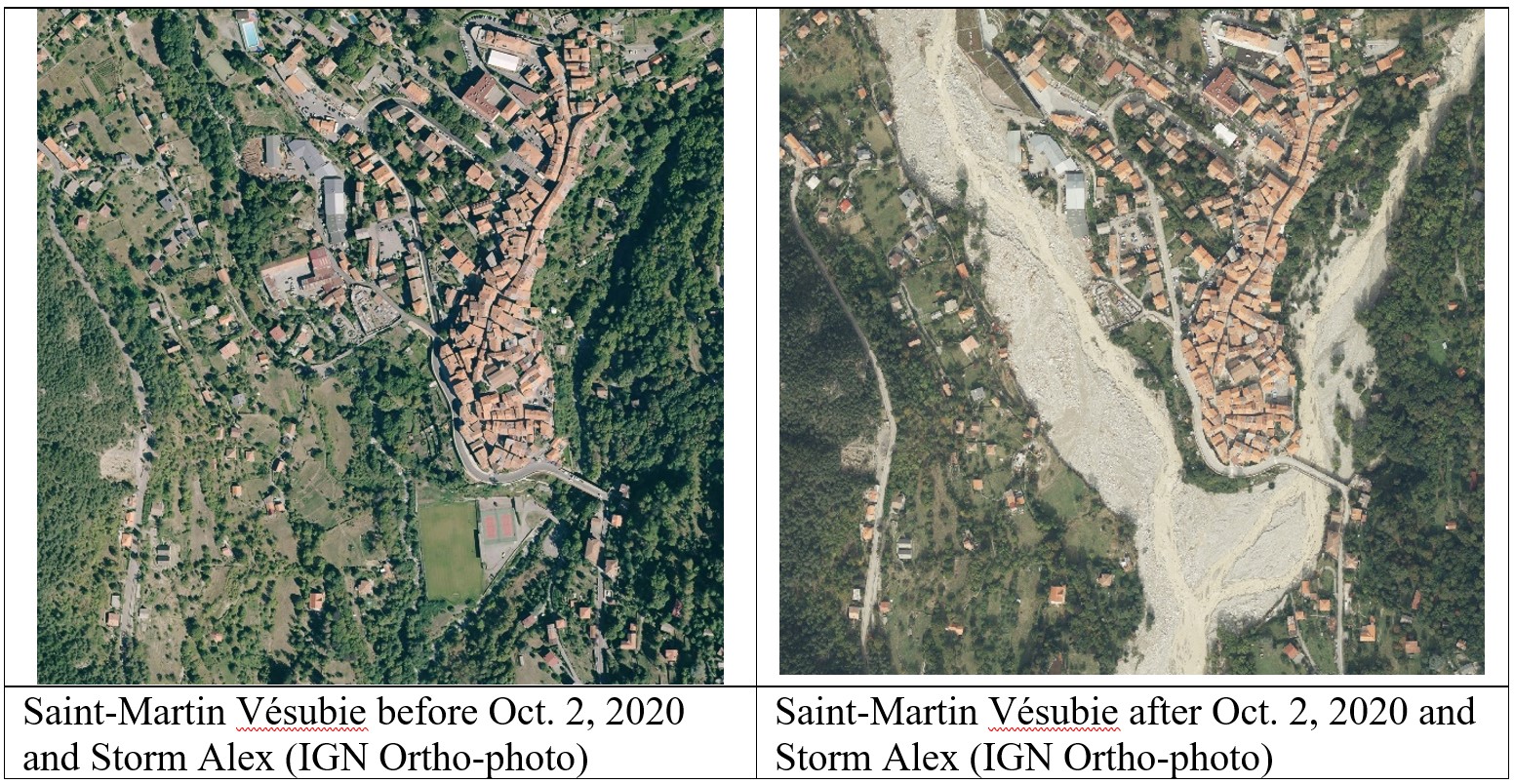
As regards landscape changes, hundreds of mass movements, large and small, occurred on the upper slopes of catchment areas. Studies therefore attempted to define the topographic conditions favorable to landslides, which included the aspect and inclination of slopes and their vertical and horizontal curvature based on different threshold conditions. This work was challenging because of the complexity of the phenomenon and the intermediate grey zone between a classic landslide and torrential flows in shallow thalwegs, where sediment movement was initiated by gravitational and runoff forces. Mass movements were initiated in two ways: 1) Slope undercutting close to the river bed and channels that widened in places by several dozen meters as torrential flows cut into soft alluvial deposits; and 2) Loading on steep south-facing upper slopes where precipitation in October normally falls as snow but was rainfall because of the warmer temperatures during Storm Alex. Once in the channel, land mass from the slopes lowered flow velocity and led to massive deposits. In Saint Martin Vésubie for example, the town’s sports complex (tennis courts and football stadium) was buried beneath a 12-meter deposit of coarse cobbles and gravel. Sediment transport dynamics in the main river channels will be affected by the new sediment distribution conditions for decades to come.
Finally, a small-scale analysis of urban development was conducted in three near-coastal catchment areas to map changes in building over a 30 year-period (1990-2020). Thousands of individual buildings were extracted from the IGN BD-TOPO database while others were digitized on screen. Urbanization growth rates were highest in the first decade and slowed over time. Three flood events (mild, moderate, extreme) were simulated to estimate the impact of urbanization on peak discharge and the number and surface area of flooded buildings for each decade. Peak discharge increased over time with all events, but the overall increase in flood risk was due more to the construction of new buildings in the flood plain than to greater peak discharge. Risk management laws appear to have been partially effective in reducing the rate of construction close to the channel starting in 2014, but further from the stream, where only extreme events can cause damage, building growth rates were fastest. In these areas, the land was further from the river channel but still relatively flat so easy to build on and close to the main road network. Most of the new large buildings close to the channel had been built with features to reduce flood damage, such as elevated floors.
The +
Several measures highlighted in the FORESEE project show that developing alternative strategies to reduce dependence on main roads, central electricity and the usual communication services can be developed and maintained as part of an ongoing strategy of preparedness well in advance of a major event.
What’s next?
Network resilience analyses should be carried out before a major event occurs to ensure better preparedness when it hits. The project is exploring the possibility of using machine learning algorithms to predict the combined impact of climate and land cover changes. Some of this work will impact future zoning rules, such as the ‘Zéro Artificialisation Nette (ZAN)’ laws which seek to freeze urban growth in the coming decades in France in order to protect natural and agricultural land cover.
Project information
|
Scientific domain
Geography, Environmental Sciences, Social sciences |
Key words Floods Participative democracy Natural hazards Land use |
|
Total budget
€63,500, including €42,700 from Academy 3
|
Start of the project
2021 |
| Partners ESPACE - Université Côte d’Azur, CNRS, AMU, AU SKEMA Business School – Sophia-Antipolis GREDEG - Université Côte d’Azur, CNRS Cerema SMIAGE CARF International collaborations: Università de Genova (UniGe) CONCERT'EAUX OPERA Interreg Alcotra project Municipalities of Mendatica and Triora |
Project members Dennis Fox Margot Chapuis Ana Pizzutti Marie Malascrabes Jean-Christophe Teobaldi Students involved Céline Martins (Master) Maleyka Asadova (Master) Chloe Campo (Master) Romain Boulinguez (Master) Mostafa Banitalebi (Master) |

Dennis Fox
ESPACE - Université Côte d’Azur, CNRS, AMU, AU

Margot Chapuis
ESPACE - Université Côte d’Azur, CNRS, AMU, AU

Ana Pizzutti
SKEMA Business School – Sophia-Antipolis

Marie Malascrabes

Scientific promotion of the project
- Fox D.M., Banitalebi M., Rainaud A., 2024. Building footprint layers show that flooding risk increased more due to greater building exposure than to greater peak discharge with urbanisation in SE France Journal of Hydrology, Regional Studies
- Fox D.M., Banitalebi M., Fournier R., Bouroubi Y., (2024). Quantifying Total Imperviousness from Building Footprint Area and Very High Resolution Air Photographs. Proceedings of the International Conference on Environmental Remote Sensing and GIS (ICERS), 11-12 July, Zagreb, Croatia.
- Liébault F., Melun G., Piton G., Chapuis M., Passy P. et Tacon S., 2024. Channel change during catastrophic flood: Example of Storm Alex in the Vésubie and Roya valleys. Geomorphology, 446. https://doi.org/10.1016/j.geomorph.2023.109008.
- Melun G., Liébault F., Piton G., Chapuis M. Passy P., Kuss D., Martins C., 2022. Crues exceptionnelles de la Vésubie et de la Roya (Oct. 2020): caractérisation hydro-géomorphologique et perspectives de gestion, I.S. Rivers, July 4-8, 2022, Lyon, France.
- Piton G., Cohen M., Flipo M., Nowak M., Chapuis M., Melun G., Robert Y., Andréis N., Liébault F., 2023. Large in-stream wood yield during an extreme flood (Storm Alex, October 2020, Roya Valley, France): estimating the supply, transport, and deposition using GIS. Geomorphology 446, ISSN 0169-555X, https://doi.org/10.1016/j.geomorph.2023.108981.
- Teobaldi J.-C., Fox D., Pizzutti A., 2023. Ces catastrophes qui marquent nos territoires et nos esprits. (Re)qualifier les territoires : promesses et actes. ERES, collection Sociétés urbaines et rurales.
- Teobaldi J.-C., Fox D., Chapuis M., 2023. Projet FORESEE: Enseignements de la tempête Alex et proposition de méthode de diagnostic territorial. MARALEX: les bassins versants maralpins face au Changement, 11 juillet, 2023, Nice, France.
