


Ionospheric Total Electron Content Tsunamimeter
A new GNSS-based technology to observe tsunamis from space and better warn the threatened populations
Academy 3 highlight
The ITEC project is at the intersection of the two main ambitions of Academy 3, “monitor and better observe Space and the Earth” and “evaluate natural and anthropogenic hazards on land and at sea”. It develops a new space-based technology to more accurately assess ocean tsunami hazards and warn the population in real time.
The project
Tsunamis cause dramatic numbers of casualties, massive economic losses and extensive destruction of coastal environments. The giant tsunami that occurred in 2011 in Japan devastated a thousand km of the Japanese coastline, claimed almost 20 000 lives, and induced more than 200 billion dollars of economic losses. Yet, even though the 2011 Japanese tsunami was one of the largest ever recorded on Earth, with wave heights up to 40 m, the forecasting systems operating in real-time failed to predict its magnitude. Eight years later, even with all the data now available on the earthquake and tsunami (seismological, geodetic, tsunami gauge data, etc.), the scientific community is still unable to accurately reproduce the actual height of the 2011 tsunami before it reached the coast.
One major reason for our current inability to model and monitor tsunamis properly is that oceans, where the tsunamis occur and propagate, are rarely instrumented, for obvious reasons: there is no emerged site on which to install permanent instrument networks.
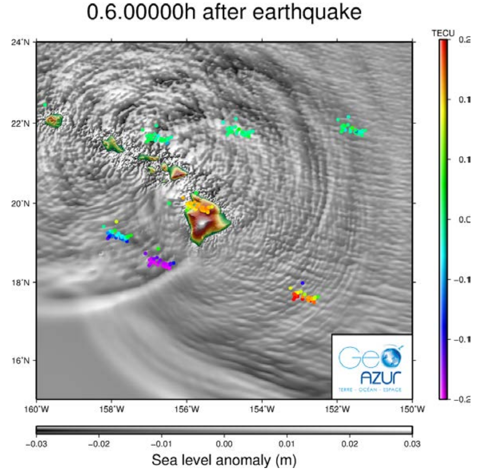
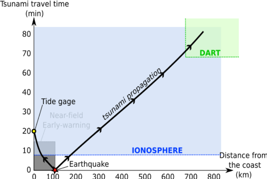
In this project, we propose to counter this problem by developing a new technology to monitor tsunamis from Space, based on the Global Navigation Satellite System (GNSS). Indeed, scientists have demonstrated in recent decades that the vertical motions produced by tsunami waves are powerful enough to create atmospheric vibrations that propagate all the way from the ocean surface up to the ionosphere, 300 kilometers up in the atmosphere, where they form a specific physical imprint. Even small tsunamis with waves only a few centimeters high imprint the ionosphere. Because the ionospheric tsunami imprint is a variation in the atmosphere electron content, it can be detected with existing GNSS networks, and thus detected all over the world, including oceans. The GNSS signals are then tracked from land with permanent or portable geodetic stations.
Our project is underway, and for the first phase we are developing the theoretical and software framework. With our US partner, we are consolidating our modeling package, IonoSeis, dedicated to the modeling of the very first ionospheric signal coming from the tsunami initiation zone (PhD work in progress). We will then design and test a GNSS-based tsunamimeter: it will be lightweight, low-power consuming, and multi-GNSS based (i.e., tracking not only GPS but also Galileo and other constellations). We anticipate that this new “instrument” will forge the way to an efficient and low-cost tsunami early-warning system.
The +
What’s next?
Initially funded by Academy 3, this project has evolved into a larger project to be funded by the ANR for four years (2020-2023). The main objective of this project is to build a prototype of tsunamimeter based on GNSS technology, designed to be integrated into future tsunami worldwide Early-Warning Systems.
Project information
|
Scientific domain
Geosciences and Environnement
Theme
Telluric hazards
|
Key words
tsunami
satellites GPS/GNSS natural hazards and risk |
|
Total budget
406.5 k€ including :
21.5 k€ from Académie 3
105 k€ PhD co-funding from CNES and OCA
280 k€ of ANR funding
|
Students inolved
Florian Zedek (PhD)
|
| Partner laboratories
Observatoire de la Côte d'Azur (OCA), Géoazur
Institut de Physique du Globe de Paris (IPGP), France International collaborations
Boise State University, Boise, USA
Indian Institute of Geomagnetism, Mumbai, Inde |
Project members
Rolland Lucie
Sladen Anthony Delouis Bertrand Pierdavide Coïsson
Philippe Lognonné
Dylan Mikesell
Mala Bagiya
|
Project valorization
Publications:
- Thomas, D., Bagiya, M. S., Sunil, P. S., Rolland, L., Sunil, A. S., Mikesell, T. D., et al. (2018). Revelation of early detection of co-seismic ionospheric perturbations in GPS-TEC from realistic modelling approach: Case study. Scientific Reports, 8(1), 12105. https://doi.org/10.1038/s41598-018-30476-9
- Mikesell, T.D.; Rolland, L.M.; Lee, R.F.; Zedek, F.; Coïsson, P.; Dessa, J.-X. IonoSeis: A Package to Model Coseismic Ionospheric Disturbances. Atmosphere 2019, 10, 443.
- Lucie Rolland, Carene S Larmat, Dylan Mikesell, Florian Zede4, Cedric Twardzik, Anthony Sladen, Quentin Bletery, Jean Mathieu Nocquet and Bertrand Delouis, Ionospheric Monitoring of Large Earthquakes Rupture Complexity with Waveform Modeling Support, AGU San Francisco, 2019
- Giovanni Occhipinti, Fabio Manta, Lucie Rolland, Lujia Feng, Emma Hill and Philippe Henri Lognonné, Tsunami risk estimation by GNSS-TEC ionospheric sounding: an additional piece of information for future tsunami warning systems , AGU San Francisco, 2019.
- Rolland, L., Zedek, F., Mikesell, D., Sladen, A., Nocquet, J. M., Coïsson, P., & Occhipinti, G. (2018, December). Contribution of Ionospheric Sounding to the Study of Large Subduction Earthquakes, the Case of the Mw 7.8 Pedernales Earthquake (2016, Ecuador). In AGU Fall Meeting Abstracts. https://agu.confex.com/agu/fm18/meetingapp.cgi/Paper/344445
- Rolland, L., Twardzik, C., Mikesell, D., Sladen, A., Delouis, B., Rivet, D., ... & Bagiya, M. S. (2018, December). Ionospheric Signature Recorded on the Hawaii GPS Network of the Mw 6.9 Earthquake and Tsunami. In AGU Fall Meeting Abstracts