


Mapping Historical Trends in Land Cover and Climate to Monitor Changes in Flooding and Forest Fire Risks
Academy 3 highlight
This project gathers experts in climatology, hydrology, economics, and physical geography to analyze the interactions between climate, land cover, forest fires, and floods. It provides a novel vision of the trends in forest fire and flooding hazards in South-East France that should help mitigate forest fire and flooding hazards with appropriate land cover planning.
The project
The PACA-TRENDS project investigates forest fires and flooding hazards in South-East France.
Forest fires depend on both weather conditions and housing densities in the Wildland Urban Interface (WUI). It is commonly expected that forest fire hazard will increase in the Euro-Mediterranean zone with warmer weather conditions and WUI expansion. However, previous studies have shown that the WUI-fire related risk has remained unexpectedly stable in South-East of France since about 1990. This is due to an increase in housing density over time: progressively, high risk isolated and scattered housing has evolved into denser, lower risk communities. In addition, firefighting efforts have had a major positive impact on fire occurrence despite warmer and drier summers. Big fires do still occur, however, in conditions of high winds, as was the case in 2003 and again in 2017. Although wind speed is of critical importance for the occurrence of large fires, nothing is known about how wind speeds have been evolving with climate change in South-East France. We thus tackle this question here. Daily wind speeds were obtained for the months of July and August for 5 weather stations located in the PACA region of France between 1960 and 2017. Wind speeds were classified into 3 categories: Low (<5 m/s), Moderate (5-10 m/s), and High (>10 m/s). We show that the number of days with High and Moderate wind conditions has decreased over time in SE France since 1960. Our results thus suggest that even though global warming might lead to more frequent fires overall, the number of very large fires in South-East France might not increase as dramatically due to fewer windy days in summer.
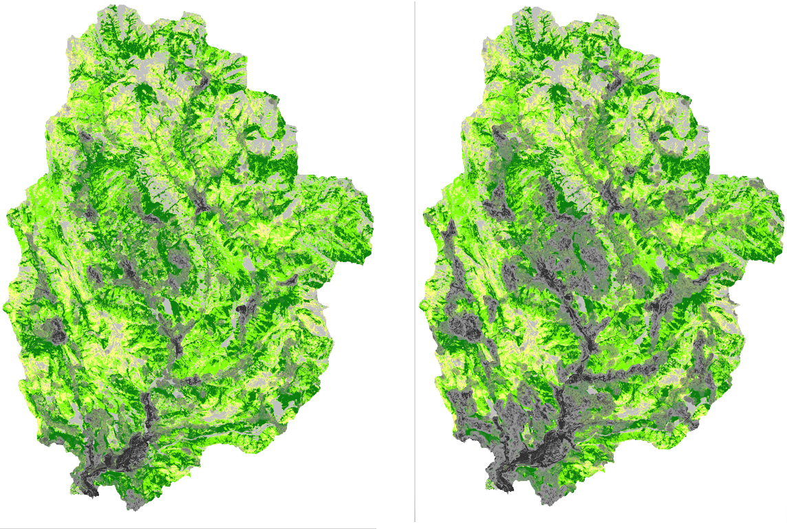
The recent catastrophic floods in Draguignan (2010) and Cannes-Biot (2015) have once again raised the question of the role of urban planning in flood severity. As natural areas are converted to impervious surfaces, infiltration of rainwater into the soil diminishes and runoff increases, thereby potentially contributing to a greater flood risk. To examine this common hypothesis, we studied 2 catchments in South-East France (Frayère and Mourachonne). Building extent and imperviousness were mapped for each catchment for 3 dates: 1988, 1999, and 2014. Runoff simulations were performed using the HEC-HMS hydrologic model. We found that changes in imperviousness over the 26-year interval increased storm runoff only marginally (about 5%). However, the built area in the flood plain increased substantially, almost twice as fast as in the catchments as a whole. We thus conclude that urban development in the catchments had little impact on flooding hazard but exposed far more buildings and people in the flood plain to potential damage, injury and loss of life.
The +
To our knowledge, this study is the first to examine how wind speeds are evolving with climate change in South-East France and to assess the relative role of imperviousness in generating runoff and increasing vulnerability. PACA-TRENDS thus provides a novel vision of the trends in forest fire and flooding hazards in South-East France that should help future planning.
What’s next?
A follow-up study, financed by the PACA region, began in September 2019 to create a real-time forest fire risk map that takes into account both climate and land cover variables. This should be a valuable alternative to the current fire weather index used to predict the likelihood of fire occurrence since the latter is based on weather data alone with no spatial representation of fire ignition probability.
Project information
|
Scientific domain
Environmental Sciences and Geography
Natural hazards and risks.
|
Key words
Flooding
Forest fires
Climate change
Land Use / Cover Change (LUCC)
|
|
Total budget
25 788 € from Academy 3.
The flooding study was carried out in the context of the
Interreg ALCOTRA Risq’Eau project. |
Students inolved
3 undergraduate student interns
|
| Partner laboratories
GEOAZUR, Université Côte d’Azur
GREDEG, Université Côte d’Azur
LJAD, Université Côte d’Azur
ARMINES
|
Project members
Dennis Fox,
Pierre Brigode,
Gerard Mondello,
Olivier Delestre,
Emmanuel Garbolino,
Pierre Carrega,
Nicolas Martin
|
Project valorization
Publication :
- Fox D. M., Youssaf Z., Adnès C., Delestre O. (accepted, 2019). Using the building footprint to model the impact of peri-urbanization on runoff in a Mediterranean catchment (1964-2014). Journal of Land Use Science. Vol. 14 (3).
Conferences:
- Fox D.M., Guyot, R., Genin J-R., Garbolino E (Solicited): Characterizing fires and fire history in the Wildland Urban Interface of south-east France. 7th International Conference on Fire Effects on Soil Properties, Haifa, 18-21 Feb., 2019.
- Fox D.M., Brigode P., Guyot, R., (Accepted). Modeling the impacts of urbanization on runoff using the building footprint (1988-2014). International Land Use Symposium 2019, 4-6 December, 2019 (Poster)