


Reflections on Forest Fires and Floods in a Context of Rapid Climate and Land Cover Changes
Publié le 4 novembre 2022 – Mis à jour le 21 novembre 2022
Authors
Dennis Foxa, Johnny Douvinetb, Clotilde Saint-Martinc, Anna Serra-Llobetd, Matthieu Vignalb
a Université Côte d'Azur, CNRS, UMR 7300 ESPACE, EUR ODYSSEE, Nice, France
b Avignon Université, CNRS, UMR 7300 ESPACES, Avignon, France
c SDIS Bouches-du-Rhône, Marseille, France
d CCRM, University of California, Berkeley, USA
I. How climate and land cover are changing at unprecedented rates
Climate change is the greatest challenge facing societies today and can be described according to three interrelated aspects: progressive temporal trends in temperature and rainfall patterns, changes in short-term weather events, and the cumulative impacts of these two components on ecosystems and societies (Donat et al., 2016). In the context of forest fires and flooding, we expect warmer temperatures will increase the duration of the forest fire season, increase burnt area in warmer and drier conditions, and expand the territorial area susceptible to burn. Rainfall events are expected to become more extreme as warmer air drives greater evaporation and increases the volume of water that can be stored in air masses before dew point temperatures are reached.Independently of climate change, land cover is undergoing rapid changes at the global scale for demographic and socio-economic reasons. Demographically, it took humans thousands of years to reach a world population of about 1 billion around 1800. Since then, in just 300 years, the population is expected to reach about 10 billion people in 2100. This exponential growth in population has several repercussions, among which we can cite the overexploitation of soil resources leading to irreversible land degradation and the need to clear forested areas, especially in equatorial regions, in order to compensate the loss of agricultural land to soil erosion and urban expansion. As population density increases, subsistence agriculture can no longer meet the needs of a growing population and people migrate to urban centres where economic prospects are better. Human migration is expected to increase as marginal dryland areas become warmer / drier and therefore less life-sustaining.
II. Forest fires
Forest fires have been an intrinsic part of some ecosystems for thousands of years. They have also been a land management tool throughout time in bush clearing practices by shepherds and slash and burn agriculture. Forest fires depend on ignition and propagation dynamics: an initial heat source must first start a fire and then environmental factors, such as temperature, wind speed, and vegetation moisture content and characteristics, determine how fast and far a fire will spread.Over the past hundred years, human-caused fire ignitions have increased dramatically through infrastructure (power lines), accidental (bush clearing, sparks, cigarettes, etc.), and intentional (gain or conflict) causes. Changes in climate and land cover converge to favour more frequent fire ignitions, and some areas of the globe, most notably Australia, California, and equatorial forests, have seen unprecedented fire seasons in recent years.
III. Post-fire flooding risks
Forest fires have implications for hydrological processes (Shakesby and Doerr, 2006). The combustion of the vegetation and litter layer leave the soil bare and exposed to rainfall, so infiltration rates are typically lower after a fire (Parise and Cannon, 2016). In addition, in some circumstances, organic molecules volatised during the fire can penetrate into the soil, condense, and form hydrophobic surface coatings on minerals. This water-repellent layer can contribute to increase runoff.Forest fires often occur on upstream forested areas that are less suitable to agriculture or urban development. Frequently, hot dry summer seasons are followed by a rainy fall season, so rainfall events fall on steep bare soils likely to generate high runoff rates. Flooding risk is low in the upland area, but runoff concentrates downstream and poses a serious risk for urban areas in alluvial plains or coastal areas which frequently have high population densities. Flooding risk is therefore greatest where the temporal sequence is a rainy season after a hot dry season and the spatial sequence is a steep forested area upslope of a flatter urban area. This temporal-spatial combination is common in Mediterranean and other environments. During extreme rainfall events, runoff can transport large quantities of coarse sediments, including boulders, which contribute to downstream damage.
IV. The Montecito case study is an iconic event (January 2018)
Montecito is a city in Santa Barbara County, California, USA, that corresponds to the spatial-temporal configuration described above (Fig. 1). In December, 2017, the Thomas fire (one of the largest wildfires in California history) extended from the ridge crest of the Santa Ynez Mountains to approximately the apex of the urbanised alluvial fans upstream of Montecito. Only 20 days later (9 Jan., 2018), the area was subjected to heavy rainfall. The event caused rapid and sudden flows consisting of mud, boulders and tree branches up to about 5 m in height, and moving at estimated speeds of up to about 30 km/h into the downstream creeks, valleys and lower areas of Montecito (Douvinet, 2022).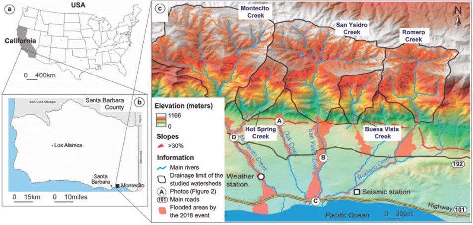
Figure 1. Location of Montecito and impacts of debris flows (adapted from Ciu et al., 2019)
The rainfall threshold for the occurrence of debris flows decreased substantially due to the high percentage of burned area in the upper catchment: this ranged from 49% within the Hit Spring Creek to 85% in San Ysidro Creek (Douvinet et al., 2020). Human, economic and environmental impacts were severe (Fig. 2). The flooding and torrential flow of boulders, mud and debris caused 21 deaths (and 2 missing persons), and 163 people were hospitalised for injuries. At least 408 homes were destroyed or damaged, and 92 structures were completely destroyed; and an additional 163 structures suffered damage. Although creeks were incised by more than 5 m into the surrounding terrain, the debris flows overflowed the valleys, often at bridge crossings, and carried boulders into neighbouring residential areas. Debris flow deposits covered around 7 km2 and the cumulative amount of sediment ranged from 297,000 m3 to up to 880,000 m3.Fortunately, before the 2018 event, Montecito had a high level of situational awareness of the risks of post-fire flooding and debris flows due to previous events (Fig. 2). Historically damaging debris flows (1914, 1926, 1934, 1964, 1969, 1971, 1990, 2002) had been recorded, and debris-flow research had been ongoing since the 1934 debris flow in Montrose that killed over 40 people. Risk awareness was demonstrated by coordinated efforts between county, state and federal agencies that included: (1) the determination of fire burn severity as a good indicator of flooding and debris-flow potential; (2) a debris-flow hazard assessment that showed a high likelihood and potential volume of debris flows from the burned areas; 3) a warning system that predicted significant to extreme potential for debris flow in the four days leading up to the storm; and (4) a proactive emergency community that coordinated evacuation orders to reduced casualties. This post-fire planning reduced the number of casualties substantially.
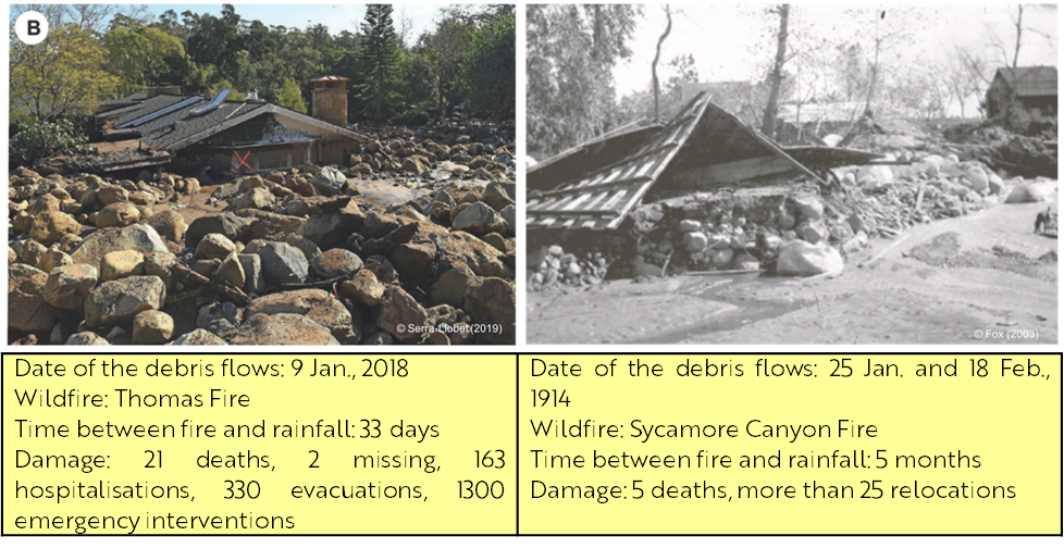
Figure 2. Impacts after the 2018 (left) and the 1914 (right) debris flows in Montecito
V. Concluding remarks
As the climate continues to change, events like the Montecito disaster and other recent similar events are expected to become more frequent. Typically, in the spring, soil moisture and warming temperatures favour vegetation regrowth, so the risk of flooding tends to decrease exponentially the first year after a large fire. The case study demonstrates the importance of crisis management preparedness. The time window between a large summer fire and intense fall storm is short, typically ranging from weeks to a few of months. Within this time frame, local authorities must quantify the risk, map the most vulnerable areas, install mitigation structures (check dams, retention basins, etc.), and prepare an evacuation strategy that can be implemented quickly and effectively when weather forecasts require. Research is needed to optimise these steps in post-fire flood management preparedness using satellite imagery, hydrological/hydraulic modelling, and organisational command chains in a multi-disciplinary approach.References
- Cui Y, Cheng D, Chan D. (2019). Investigation of post-fire debris flows in Montecito. Geo-information. 8 (5).
- Donat M, Lowry A, Alexander L, Ogorman P, Maher N. (2016). More extreme precipitation in the world’s dry and wet regions. Nature Climate Change. 6 508-513
- Douvinet J. (2022). Post-Fire Debris Flow Susceptibility Assessment Tracking the “Cauliflower effect”: A Case Study in Montecito, USA, in Floods - Understanding Existing and Emerging Risk Drivers in a Climate Change Context, edited by Dr. Tiago Miguel Ferreira IntechOpen, 13 p.
- Douvinet J., Serra-Llobet A., Radke J., and Kondolf M. (2020). Quels enseignements tirer des coulées de débris post-incendie survenues le 9 janvier 2018 à Montecito (Californie, USA)?, La Houille Blanche, Revue International de l’Eau, 6, 25-25.
- Parise M, and Cannon S. Wildfire impacts on the processes that generate debris flows in burned watersheds. Natural Hazards. 61(1),, 217-227.
- Shakesby R.A., and Doerr S.H. (2006). Wildfire as a hydrological and geomorphological agent. Earth-Science Reviews, 74, 269-307.